El Buzón geodata
El Buzón (Veracruz) is a populated place; located in Mexico in America/Mexico_City (GMT-6) time zone. With population of 642 people, there are 13481 cities with bigger population in this country. Compared to other cities in Mexico, 62% of cities are located further ↑North; 80.6% of cities are located further ←West and 88.3% of cities have higher elevation than El Buzón. Note1


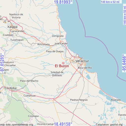
El Buzón GPS coordinates[2]
19° 9' 25.524" North, 96° 20' 58.992" West
| Map corner | latitude | longitude |
|---|---|---|
| Upper-left | 19.81993°, | -97.05285° |
| Center: | 19.15709°, | -96.34972° |
| Lower-right: | 18.49158°, | -95.6466° |
| Map W x H: | 147.7×147.7 km | = 91.8×91.8mi |
| max Lat: | 32.7° ⇑62% North |
| El Buzón: | 19.15709° |
| min Lat: | ⇓38% South 14.53588° |
| min Long | El Buzón | max Long |
| -117.105° | -96.34972° | -86.73105° |
| W 80.6%⇐ | ⇒19.4% E |
Elevation
Elevation of El Buzón is 29 m = 95 ft, and this is 1224.7 m = 4018 ft below average elevation for this country.
| Max E: |
3497 m = 11473 ft | 88.3% |
| Avg. | 1253.7 m = 4113 ft | |
| El Buzón | 29 m = 95 ft | |
Min E: |
-1 m = -3 ft | 11.7% |
See also: Mexico elevation on elevation.city.
Geographical zone
El Buzón is located in North Torrid zone (between Equator and Tropic of Cancer). Distance of this Northern Tropic circle is 475.9 km =295.7 mi to North.| Distance of | km | miles | from El Buzón |
|---|---|---|---|
| North Pole | 7877 | 4894.5 | to North |
| Arctic Circle | 5271.1 | 3275.3 | to North |
| Tropic Cancer | 475.9 | 295.7 | to North |
| Equator | 2130.1 | 1323.6 | to South |


Nearby cities:
15 places around El Buzón: (largest is in red/bold)
• Belisario Domínguez
2.1 km =1.3 mi,  42°
42°
• Cabo Verde
5.4 km =3.4 mi,  71°
71°
• El Pando
7.6 km =4.7 mi,  56°
56°
• El Sauce
6.6 km =4.1 mi,  196°
196°
• Loma de los Carmona
7.4 km =4.6 mi,  218°
218°
• Loma del Nanche
6.1 km =3.8 mi,  323°
323°
• Manlio Fabio Altamirano
7.2 km =4.5 mi,  166°
166°
• Mata Loma
6.3 km =3.9 mi,  116°
116°
• Paso Real
3.2 km =2 mi,  334°
334°
• Paso San Juan
5.7 km =3.5 mi,  28°
28°
• Plan del Manantial
7.4 km =4.6 mi,  340°
340°
• Puente Jula
4.8 km =3 mi,  1°
1°
• Tenenexpan
5 km =3.1 mi,  249°
249°
• Tierra Colorada
7.9 km =4.9 mi, 344°
• Vargas
8.4 km =5.2 mi,  21°
21°
Sources, notices
• [Note1] Compared only with cities in Mexico existing in our database
• [Src1] Map data: © OpenStreetMap contributors (CC-BY-SA)
• [Src2] Other city data from geonames.org with taken over terms of usage.
• [Src3] Geographical zone / Annual Mean Temperature by Robert A. Rohde @ Wikipedia
