Mata Cazuela geodata
Mata Cazuela (Veracruz) is a populated place; located in Mexico in America/Mexico_City (GMT-6) time zone. With population of 870 people, there are 10041 cities with bigger population in this country. Compared to other cities in Mexico, 62.2% of cities are located further ↑North; 80% of cities are located further ←West and 77.5% of cities have higher elevation than Mata Cazuela. Note1


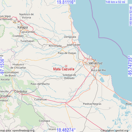
Mata Cazuela GPS coordinates[2]
19° 8' 53.844" North, 96° 27' 1.692" West
| Map corner | latitude | longitude |
|---|---|---|
| Upper-left | 19.81116°, | -97.1536° |
| Center: | 19.14829°, | -96.45047° |
| Lower-right: | 18.48274°, | -95.74735° |
| Map W x H: | 147.7×147.7 km | = 91.8×91.8mi |
| max Lat: | 32.7° ⇑62.2% North |
| Mata Cazuela: | 19.14829° |
| min Lat: | ⇓37.8% South 14.53588° |
| min Long | Mata Cazuela | max Long |
| -117.105° | -96.45047° | -86.73105° |
| W 80%⇐ | ⇒20% E |
Elevation
Elevation of Mata Cazuela is 142 m = 466 ft, and this is 1111.7 m = 3647 ft below average elevation for this country.
| Max E: |
3497 m = 11473 ft | 77.5% |
| Avg. | 1253.7 m = 4113 ft | |
| Mata Cazuela | 142 m = 466 ft | |
Min E: |
-1 m = -3 ft | 22.5% |
See also: Mexico elevation on elevation.city.
Geographical zone
Mata Cazuela is located in North Torrid zone (between Equator and Tropic of Cancer). Distance of this Northern Tropic circle is 476.8 km =296.3 mi to North.| Distance of | km | miles | from Mata Cazuela |
|---|---|---|---|
| North Pole | 7878 | 4895.2 | to North |
| Arctic Circle | 5272.1 | 3275.9 | to North |
| Tropic Cancer | 476.8 | 296.3 | to North |
| Equator | 2129.1 | 1323 | to South |


Nearby cities:
15 places around Mata Cazuela: (largest is in red/bold)
• Bandera de Juárez
6.3 km =3.9 mi,  27°
27°
• El Buzón
10.6 km =6.6 mi,  84°
84°
• El Pochote
9.4 km =5.8 mi, 32°
• El Sauce
10.2 km =6.3 mi,  121°
121°
• Loma de los Carmona
7.6 km =4.7 mi,  128°
128°
• Loma del Nanche
9.1 km =5.7 mi,  49°
49°
• Palmaritos
9.1 km =5.7 mi, 27°
• Paso Lagarto
7.9 km =4.9 mi,  227°
227°
• Paso Real
10 km =6.2 mi,  67°
67°
• Plan del Manantial
11.3 km =7 mi, 45°
• Puente Jula
12.2 km =7.6 mi,  61°
61°
• Remojadas
10 km =6.2 mi,  139°
139°
• Soledad de Doblado
11.7 km =7.3 mi,  164°
164°
• Tenenexpan
5.9 km =3.7 mi,  97°
97°
• Tierra Colorada
12.1 km =7.5 mi,  44°
44°
Sources, notices
• [Note1] Compared only with cities in Mexico existing in our database
• [Src1] Map data: © OpenStreetMap contributors (CC-BY-SA)
• [Src2] Other city data from geonames.org with taken over terms of usage.
• [Src3] Geographical zone / Annual Mean Temperature by Robert A. Rohde @ Wikipedia
