Rafael Delgado geodata
Rafael Delgado (Veracruz) is a seat of a second-order administrative division; located in Mexico in America/Mexico_City (GMT-6) time zone. With population of 9,594 people, there are 998 cities with bigger population in this country. Compared to other cities in Mexico, 68.6% of cities are located further ↑North; 73.9% of cities are located further ←West and 55.7% of cities have higher elevation than Rafael Delgado. Note1


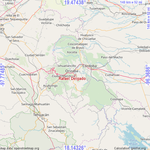
Rafael Delgado GPS coordinates[2]
18° 48' 36.504" North, 97° 4' 18.192" West
| Map corner | latitude | longitude |
|---|---|---|
| Upper-left | 19.47438°, | -97.77485° |
| Center: | 18.81014°, | -97.07172° |
| Lower-right: | 18.14326°, | -96.3686° |
| Map W x H: | 148×148 km | = 92×92mi |
| max Lat: | 32.7° ⇑68.6% North |
| Rafael Delgado: | 18.81014° |
| min Lat: | ⇓31.4% South 14.53588° |
| min Long | Rafael Delgado | max Long |
| -117.105° | -97.07172° | -86.73105° |
| W 73.9%⇐ | ⇒26.1% E |
Elevation
Elevation of Rafael Delgado is 1171 m = 3842 ft, and this is 82.7 m = 271 ft below average elevation for this country.
| Max E: |
3497 m = 11473 ft | 55.7% |
| Avg. | 1253.7 m = 4113 ft | |
| Rafael Delgado | 1171 m = 3842 ft | |
Min E: |
-1 m = -3 ft | 44.3% |
See also: Mexico elevation on elevation.city.
Geographical zone
Rafael Delgado is located in North Torrid zone (between Equator and Tropic of Cancer). Distance of this Northern Tropic circle is 514.4 km =319.6 mi to North.| Distance of | km | miles | from Rafael Delgado |
|---|---|---|---|
| North Pole | 7915.6 | 4918.5 | to North |
| Arctic Circle | 5309.7 | 3299.3 | to North |
| Tropic Cancer | 514.4 | 319.6 | to North |
| Equator | 2091.5 | 1299.6 | to South |


Nearby cities:
15 places around Rafael Delgado: (largest is in red/bold)
• Campo Chico
5.4 km =3.4 mi,  57°
57°
• Campo Grande
6.4 km =4 mi,  77°
77°
• Capoluca
4.7 km =2.9 mi,  95°
95°
• Capultitla
6.5 km =4 mi,  152°
152°
• Donato Guerra
4.1 km =2.5 mi,  299°
299°
• Ixtaczoquitlán
4.9 km =3 mi,  11°
11°
• Jalapilla
2.5 km =1.6 mi,  315°
315°
• Magdalena
6.1 km =3.8 mi, 153°
• Orizaba
5.5 km =3.4 mi,  327°
327°
• San Andrés Tenejapan
3.3 km =2.1 mi,  225°
225°
• San Cristóbal
5.9 km =3.7 mi,  291°
291°
• Tlilapan
2.9 km =1.8 mi,  259°
259°
• Tonalixco
3.4 km =2.1 mi,  158°
158°
• Tuxpanguillo
6.9 km =4.3 mi,  116°
116°
• Zoquitlán Viejo
3.4 km =2.1 mi,  38°
38°
Sources, notices
• [Note1] Compared only with cities in Mexico existing in our database
• [Src1] Map data: © OpenStreetMap contributors (CC-BY-SA)
• [Src2] Other city data from geonames.org with taken over terms of usage.
• [Src3] Geographical zone / Annual Mean Temperature by Robert A. Rohde @ Wikipedia
