Perote geodata
Perote (Veracruz) is a seat of a second-order administrative division; located in Mexico in America/Mexico_City (GMT-6) time zone. With population of 37,516 people, there are 275 cities with bigger population in this country. Compared to other cities in Mexico, 52.8% of cities are located further ↑North; 72.1% of cities are located further ←West and 90.3% of cities have lower elevation than Perote. Note1


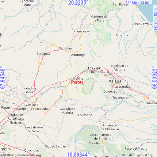
Perote GPS coordinates[2]
19° 33' 44.388" North, 97° 14' 32.46" West
| Map corner | latitude | longitude |
|---|---|---|
| Upper-left | 20.2235°, | -97.94548° |
| Center: | 19.56233°, | -97.24235° |
| Lower-right: | 18.89844°, | -96.53923° |
| Map W x H: | 147.3×147.3 km | = 91.5×91.5mi |
| max Lat: | 32.7° ⇑52.8% North |
| Perote: | 19.56233° |
| min Lat: | ⇓47.2% South 14.53588° |
| min Long | Perote | max Long |
| -117.105° | -97.24235° | -86.73105° |
| W 72.1%⇐ | ⇒27.9% E |
Elevation
Elevation of Perote is 2416 m = 7927 ft, and this is 1162.3 m = 3813 ft above average elevation for this country.
| Max E: |
3497 m = 11473 ft | 9.7% |
| Perote | 2416 m 7927 ft | |
| Avg. | 1253.7 m = 4113 ft | |
Min E: |
-1 m = -3 ft | 90.3% |
See also: Mexico elevation on elevation.city.
Geographical zone
Perote is located in North Torrid zone (between Equator and Tropic of Cancer). Distance of this Northern Tropic circle is 430.8 km =267.7 mi to North.| Distance of | km | miles | from Perote |
|---|---|---|---|
| North Pole | 7831.9 | 4866.5 | to North |
| Arctic Circle | 5226 | 3247.3 | to North |
| Tropic Cancer | 430.8 | 267.7 | to North |
| Equator | 2175.1 | 1351.5 | to South |


Nearby cities:
15 places around Perote: (largest is in red/bold)
• Centro de Readaptación Social
7.3 km =4.5 mi,  18°
18°
• Cerro de León
8.3 km =5.2 mi,  25°
25°
• Colonia Benito Juárez
11.1 km =6.9 mi,  54°
54°
• Cruz Blanca
11.5 km =7.1 mi,  43°
43°
• El Conejo
9.9 km =6.2 mi,  110°
110°
• El Escobillo
7.1 km =4.4 mi,  138°
138°
• Francisco I. Madero
4.9 km =3 mi,  217°
217°
• Frijol Colorado
11.9 km =7.4 mi,  284°
284°
• Guadalupe Victoria
4.4 km =2.7 mi,  238°
238°
• Libertad
2.2 km =1.4 mi, 218°
• Los Molinos
4.7 km =2.9 mi, 37°
• Los Pescados
9.8 km =6.1 mi,  90°
90°
• Magueyitos
9.8 km =6.1 mi,  357°
357°
• Sierra de Agua
6.5 km =4 mi, 42°
• Villa Aldama
9.8 km =6.1 mi,  11°
11°
Sources, notices
• [Note1] Compared only with cities in Mexico existing in our database
• [Src1] Map data: © OpenStreetMap contributors (CC-BY-SA)
• [Src2] Other city data from geonames.org with taken over terms of usage.
• [Src3] Geographical zone / Annual Mean Temperature by Robert A. Rohde @ Wikipedia
