Paso San Juan geodata
Paso San Juan (Veracruz) is a populated place; located in Mexico in America/Mexico_City (GMT-6) time zone. With population of 679 people, there are 12793 cities with bigger population in this country. Compared to other cities in Mexico, 61.2% of cities are located further ↑North; 80.7% of cities are located further ←West and 90.8% of cities have higher elevation than Paso San Juan. Note1


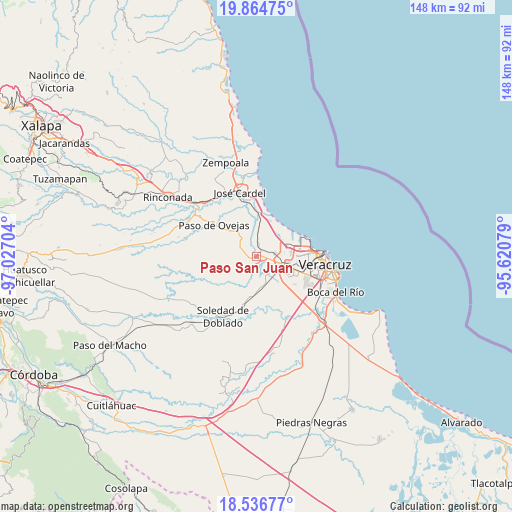
Paso San Juan GPS coordinates[2]
19° 12' 7.56" North, 96° 19' 26.076" West
| Map corner | latitude | longitude |
|---|---|---|
| Upper-left | 19.86475°, | -97.02704° |
| Center: | 19.2021°, | -96.32391° |
| Lower-right: | 18.53677°, | -95.62079° |
| Map W x H: | 147.7×147.7 km | = 91.8×91.8mi |
| max Lat: | 32.7° ⇑61.2% North |
| Paso San Juan: | 19.2021° |
| min Lat: | ⇓38.8% South 14.53588° |
| min Long | Paso San Juan | max Long |
| -117.105° | -96.32391° | -86.73105° |
| W 80.7%⇐ | ⇒19.3% E |
Elevation
Elevation of Paso San Juan is 22 m = 72 ft, and this is 1231.7 m = 4041 ft below average elevation for this country.
| Max E: |
3497 m = 11473 ft | 90.8% |
| Avg. | 1253.7 m = 4113 ft | |
| Paso San Juan | 22 m = 72 ft | |
Min E: |
-1 m = -3 ft | 9.2% |
See also: Mexico elevation on elevation.city.
Geographical zone
Paso San Juan is located in North Torrid zone (between Equator and Tropic of Cancer). Distance of this Northern Tropic circle is 470.8 km =292.5 mi to North.| Distance of | km | miles | from Paso San Juan |
|---|---|---|---|
| North Pole | 7872 | 4891.4 | to North |
| Arctic Circle | 5266.1 | 3272.2 | to North |
| Tropic Cancer | 470.8 | 292.5 | to North |
| Equator | 2135.1 | 1326.7 | to South |


Nearby cities:
15 places around Paso San Juan: (largest is in red/bold)
• Belisario Domínguez
3.7 km =2.3 mi,  200°
200°
• Cabo Verde
4.1 km =2.5 mi,  143°
143°
• Cerro Guzmán
6.8 km =4.2 mi,  302°
302°
• Delfino Victoria (Santa Fe)
5.3 km =3.3 mi,  83°
83°
• El Buzón
5.7 km =3.5 mi,  208°
208°
• El Pando
3.7 km =2.3 mi,  101°
101°
• Loma del Nanche
6.4 km =4 mi,  268°
268°
• Mata Loma
8.4 km =5.2 mi,  159°
159°
• Paso Real
4.6 km =2.9 mi,  242°
242°
• Plan del Manantial
5.5 km =3.4 mi,  290°
290°
• Puente Jula
2.6 km =1.6 mi, 265°
• San Julián
8.5 km =5.3 mi,  44°
44°
• Santa Rita
7.7 km =4.8 mi,  119°
119°
• Tierra Colorada
5.4 km =3.4 mi, 298°
• Vargas
2.9 km =1.8 mi,  7°
7°
Sources, notices
• [Note1] Compared only with cities in Mexico existing in our database
• [Src1] Map data: © OpenStreetMap contributors (CC-BY-SA)
• [Src2] Other city data from geonames.org with taken over terms of usage.
• [Src3] Geographical zone / Annual Mean Temperature by Robert A. Rohde @ Wikipedia
