Oxtotipac geodata
Oxtotipac (State of Mexico) is a populated place; located in Mexico in America/Mexico_City (GMT-6) time zone. With population of 3,081 people, there are 2925 cities with bigger population in this country. Compared to other cities in Mexico, 50.7% of cities are located further ↑North; 53.7% of cities are located further ←West and 89.2% of cities have lower elevation than Oxtotipac. Note1


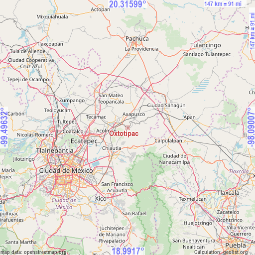
Oxtotipac GPS coordinates[2]
19° 39' 18.756" North, 98° 47' 35.484" West
| Map corner | latitude | longitude |
|---|---|---|
| Upper-left | 20.31599°, | -99.49632° |
| Center: | 19.65521°, | -98.79319° |
| Lower-right: | 18.9917°, | -98.09007° |
| Map W x H: | 147.2×147.2 km | = 91.5×91.5mi |
| max Lat: | 32.7° ⇑50.7% North |
| Oxtotipac: | 19.65521° |
| min Lat: | ⇓49.3% South 14.53588° |
| min Long | Oxtotipac | max Long |
| -117.105° | -98.79319° | -86.73105° |
| W 53.7%⇐ | ⇒46.3% E |
Elevation
Elevation of Oxtotipac is 2380 m = 7808 ft, and this is 1126.3 m = 3695 ft above average elevation for this country.
| Max E: |
3497 m = 11473 ft | 10.8% |
| Oxtotipac | 2380 m 7808 ft | |
| Avg. | 1253.7 m = 4113 ft | |
Min E: |
-1 m = -3 ft | 89.2% |
See also: Mexico elevation on elevation.city.
Geographical zone
Oxtotipac is located in North Torrid zone (between Equator and Tropic of Cancer). Distance of this Northern Tropic circle is 420.5 km =261.3 mi to North.| Distance of | km | miles | from Oxtotipac |
|---|---|---|---|
| North Pole | 7821.6 | 4860.1 | to North |
| Arctic Circle | 5215.7 | 3240.9 | to North |
| Tropic Cancer | 420.5 | 261.3 | to North |
| Equator | 2185.5 | 1358 | to South |


Nearby cities:
15 places around Oxtotipac: (largest is in red/bold)
• Belem
2.5 km =1.6 mi,  188°
188°
• Cuautlacingo
4.4 km =2.7 mi,  12°
12°
• Ejido San Martín
7.6 km =4.7 mi,  328°
328°
• Ejido de San Sebastián
5.2 km =3.2 mi,  286°
286°
• Otumba
6.3 km =3.9 mi,  37°
37°
• San Francisco Mazapa
5.9 km =3.7 mi,  313°
313°
• San Francisco Tlaltica
1.9 km =1.2 mi,  79°
79°
• San Lucas Tepango
7.1 km =4.4 mi,  261°
261°
• San Martín Ahuatepec
7.4 km =4.6 mi,  66°
66°
• San Martín de las Pirámides
7.2 km =4.5 mi,  321°
321°
• San Pablo Ixquitlán
6.1 km =3.8 mi,  4°
4°
• San Sebastián Xolalpa
5.9 km =3.7 mi, 293°
• Santiago Tepetitlán
3.3 km =2.1 mi,  234°
234°
• Tlahuico
4.2 km =2.6 mi,  64°
64°
• Tlalmimilolpan
4.7 km =2.9 mi,  54°
54°
Sources, notices
• [Note1] Compared only with cities in Mexico existing in our database
• [Src1] Map data: © OpenStreetMap contributors (CC-BY-SA)
• [Src2] Other city data from geonames.org with taken over terms of usage.
• [Src3] Geographical zone / Annual Mean Temperature by Robert A. Rohde @ Wikipedia
