Nilchí geodata
Nilchí (Campeche) is a populated place; located in Mexico in America/Merida (GMT-6) time zone. With population of 900 people, there are 9690 cities with bigger population in this country. Compared to other cities in Mexico, 54% of cities are located further ↓South; 97.3% of cities are located further ←West and 96.3% of cities have higher elevation than Nilchí. Note1


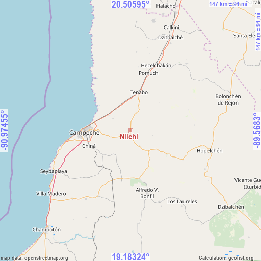
Nilchí GPS coordinates[2]
19° 50' 45.492" North, 90° 16' 17.112" West
| Map corner | latitude | longitude |
|---|---|---|
| Upper-left | 20.50595°, | -90.97455° |
| Center: | 19.84597°, | -90.27142° |
| Lower-right: | 19.18324°, | -89.5683° |
| Map W x H: | 147.1×147.1 km | = 91.4×91.4mi |
| max Lat: | 32.7° ⇑46% North |
| Nilchí: | 19.84597° |
| min Lat: | ⇓54% South 14.53588° |
| min Long | Nilchí | max Long |
| -117.105° | -90.27142° | -86.73105° |
| W 97.3%⇐ | ⇒2.7% E |
Elevation
Elevation of Nilchí is 11 m = 36 ft, and this is 1242.7 m = 4077 ft below average elevation for this country.
| Max E: |
3497 m = 11473 ft | 96.3% |
| Avg. | 1253.7 m = 4113 ft | |
| Nilchí | 11 m = 36 ft | |
Min E: |
-1 m = -3 ft | 3.7% |
See also: Mexico elevation on elevation.city.
Geographical zone
Nilchí is located in North Torrid zone (between Equator and Tropic of Cancer). Distance of this Northern Tropic circle is 399.3 km =248.1 mi to North.| Distance of | km | miles | from Nilchí |
|---|---|---|---|
| North Pole | 7800.4 | 4846.9 | to North |
| Arctic Circle | 5194.5 | 3227.7 | to North |
| Tropic Cancer | 399.3 | 248.1 | to North |
| Equator | 2206.7 | 1371.2 | to South |


Nearby cities:
15 places around Nilchí: (largest is in red/bold)
• Bethania
12.1 km =7.5 mi,  304°
304°
• Campeche
26.6 km =16.5 mi,  269°
269°
• Castamay
16.8 km =10.4 mi, 266°
• Chemblás
12.1 km =7.5 mi,  313°
313°
• Chiná
25 km =15.5 mi,  250°
250°
• Crucero San Luis
33.6 km =20.9 mi,  118°
118°
• Hampolol
15.3 km =9.5 mi, 306°
• Nohakal
22.4 km =13.9 mi,  197°
197°
• Pocyaxum
15.4 km =9.6 mi,  212°
212°
• Pomuch
33.9 km =21.1 mi,  17°
17°
• San Francisco Kobén
17.1 km =10.6 mi, 296°
• Suc-Tuc
28.6 km =17.8 mi, 121°
• Tenabo
22.1 km =13.7 mi,  12°
12°
• Tikinmul
10.2 km =6.3 mi,  150°
150°
• Tinún
14 km =8.7 mi, 19°
Sources, notices
• [Note1] Compared only with cities in Mexico existing in our database
• [Src1] Map data: © OpenStreetMap contributors (CC-BY-SA)
• [Src2] Other city data from geonames.org with taken over terms of usage.
• [Src3] Geographical zone / Annual Mean Temperature by Robert A. Rohde @ Wikipedia
