Crucero San Luis geodata
Crucero San Luis (Campeche) is a populated place; located in Mexico in America/Merida (GMT-6) time zone. With population of 641 people, there are 13506 cities with bigger population in this country. Compared to other cities in Mexico, 50.4% of cities are located further ↓South; 97.6% of cities are located further ←West and 79.8% of cities have higher elevation than Crucero San Luis. Note1


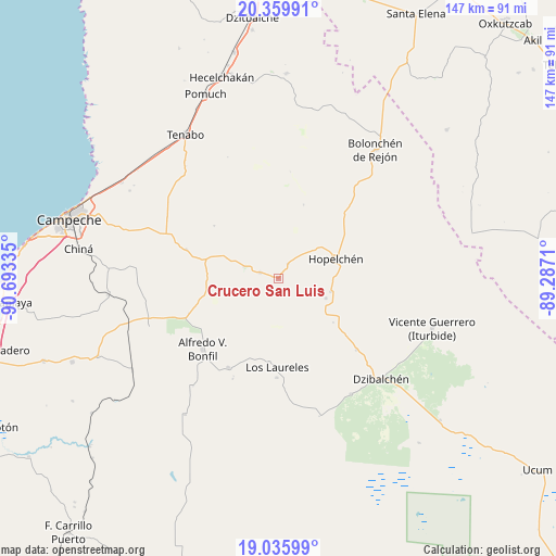
Crucero San Luis GPS coordinates[2]
19° 41' 57.552" North, 89° 59' 24.792" West
| Map corner | latitude | longitude |
|---|---|---|
| Upper-left | 20.35991°, | -90.69335° |
| Center: | 19.69932°, | -89.99022° |
| Lower-right: | 19.03599°, | -89.2871° |
| Map W x H: | 147.2×147.2 km | = 91.5×91.5mi |
| max Lat: | 32.7° ⇑49.6% North |
| Crucero San Luis: | 19.69932° |
| min Lat: | ⇓50.4% South 14.53588° |
| min Long | Crucero San Lui | max Long |
| -117.105° | -89.99022° | -86.73105° |
| W 97.6%⇐ | ⇒2.4% E |
Elevation
Elevation of Crucero San Luis is 98 m = 322 ft, and this is 1155.7 m = 3792 ft below average elevation for this country.
| Max E: |
3497 m = 11473 ft | 79.8% |
| Avg. | 1253.7 m = 4113 ft | |
| Crucero San Luis | 98 m = 322 ft | |
Min E: |
-1 m = -3 ft | 20.2% |
See also: Mexico elevation on elevation.city.
Geographical zone
Crucero San Luis is located in North Torrid zone (between Equator and Tropic of Cancer). Distance of this Northern Tropic circle is 415.6 km =258.2 mi to North.| Distance of | km | miles | from Crucero San Luis |
|---|---|---|---|
| North Pole | 7816.7 | 4857.1 | to North |
| Arctic Circle | 5210.8 | 3237.8 | to North |
| Tropic Cancer | 415.6 | 258.2 | to North |
| Equator | 2190.4 | 1361.1 | to South |


Nearby cities:
15 places around Crucero San Luis: (largest is in red/bold)
• Alfredo V. Bonfil
27.5 km =17.1 mi,  226°
226°
• Dzibalchén
38.1 km =23.7 mi,  134°
134°
• Hopelchén
16.1 km =10 mi,  70°
70°
• Ich-Ek
4.5 km =2.8 mi,  33°
33°
• Konchén
18.6 km =11.6 mi, 128°
• Los Laureles
23.5 km =14.6 mi,  181°
181°
• Nilchí
33.6 km =20.9 mi,  298°
298°
• Nohakal
36.5 km =22.7 mi,  262°
262°
• Pich
27.3 km =17 mi,  209°
209°
• Pocyaxum
37.8 km =23.5 mi,  274°
274°
• Quetzal Edzná
29.4 km =18.3 mi,  204°
204°
• Santa Rita
13.6 km =8.5 mi,  113°
113°
• Suc-Tuc
5.2 km =3.2 mi,  286°
286°
• Tikinmul
25.5 km =15.8 mi, 286°
• Xcupil
14.2 km =8.8 mi, 105°
Sources, notices
• [Note1] Compared only with cities in Mexico existing in our database
• [Src1] Map data: © OpenStreetMap contributors (CC-BY-SA)
• [Src2] Other city data from geonames.org with taken over terms of usage.
• [Src3] Geographical zone / Annual Mean Temperature by Robert A. Rohde @ Wikipedia
