Montecillo geodata
Montecillo (State of Mexico) is a populated place; located in Mexico in America/Mexico_City (GMT-6) time zone. With population of 7,371 people, there are 1258 cities with bigger population in this country. Compared to other cities in Mexico, 54.9% of cities are located further ↑North; 51.8% of cities are located further ←West and 84.2% of cities have lower elevation than Montecillo. Note1


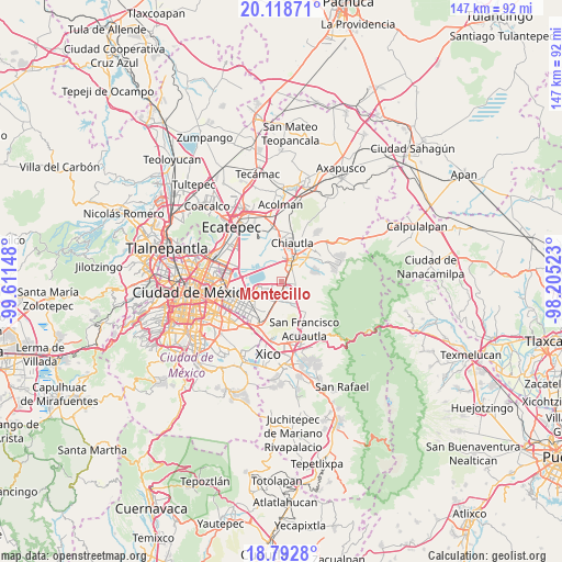
Montecillo GPS coordinates[2]
19° 27' 25.596" North, 98° 54' 30.06" West
| Map corner | latitude | longitude |
|---|---|---|
| Upper-left | 20.11871°, | -99.61148° |
| Center: | 19.45711°, | -98.90835° |
| Lower-right: | 18.7928°, | -98.20523° |
| Map W x H: | 147.4×147.4 km | = 91.6×91.6mi |
| max Lat: | 32.7° ⇑54.9% North |
| Montecillo: | 19.45711° |
| min Lat: | ⇓45.1% South 14.53588° |
| min Long | Montecillo | max Long |
| -117.105° | -98.90835° | -86.73105° |
| W 51.8%⇐ | ⇒48.2% E |
Elevation
Elevation of Montecillo is 2245 m = 7365 ft, and this is 991.3 m = 3252 ft above average elevation for this country.
| Max E: |
3497 m = 11473 ft | 15.8% |
| Montecillo | 2245 m 7365 ft | |
| Avg. | 1253.7 m = 4113 ft | |
Min E: |
-1 m = -3 ft | 84.2% |
See also: Mexico elevation on elevation.city.
Geographical zone
Montecillo is located in North Torrid zone (between Equator and Tropic of Cancer). Distance of this Northern Tropic circle is 442.5 km =275 mi to North.| Distance of | km | miles | from Montecillo |
|---|---|---|---|
| North Pole | 7843.6 | 4873.8 | to North |
| Arctic Circle | 5237.7 | 3254.6 | to North |
| Tropic Cancer | 442.5 | 275 | to North |
| Equator | 2163.4 | 1344.3 | to South |


Nearby cities:
15 places around Montecillo: (largest is in red/bold)
• Chicoloapan
4.5 km =2.8 mi,  171°
171°
• Colonia Guadalupe Victoria
4.8 km =3 mi,  346°
346°
• Colonia Lázaro Cárdenas
1.3 km =0.8 mi,  162°
162°
• Colonia Lázaro Cárdenas
6.3 km =3.9 mi, 348°
• Colonia Villas de Tolimpa
3.2 km =2 mi,  52°
52°
• Colonia las Tijeras
4.1 km =2.5 mi,  81°
81°
• Ejido la Venta Cuautlalpan
5.5 km =3.4 mi,  139°
139°
• Ejidos de Beltrán Cuautlalpan
1.2 km =0.7 mi,  259°
259°
• Rancho la Cabaña
3.6 km =2.2 mi, 160°
• San Bernardino
2.5 km =1.6 mi,  30°
30°
• San Miguel Coatlinchán
3.8 km =2.4 mi,  101°
101°
• Santa Martha
3 km =1.9 mi,  198°
198°
• Santa María Chimalhuacán
5.9 km =3.7 mi,  228°
228°
• Santiago Cuautlalpan
2.9 km =1.8 mi, 165°
• Texcoco de Mora
6.7 km =4.2 mi,  23°
23°
Sources, notices
• [Note1] Compared only with cities in Mexico existing in our database
• [Src1] Map data: © OpenStreetMap contributors (CC-BY-SA)
• [Src2] Other city data from geonames.org with taken over terms of usage.
• [Src3] Geographical zone / Annual Mean Temperature by Robert A. Rohde @ Wikipedia
