Chicoloapan geodata
Chicoloapan (State of Mexico) is a seat of a second-order administrative division; located in Mexico in America/Mexico_City (GMT-6) time zone. With population of 172,919 people, there are 92 cities with bigger population in this country. Compared to other cities in Mexico, 55.9% of cities are located further ↑North; 51.9% of cities are located further ←West and 84.4% of cities have lower elevation than Chicoloapan. Note1


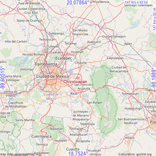
Chicoloapan GPS coordinates[2]
19° 25' 0.732" North, 98° 54' 7.272" West
| Map corner | latitude | longitude |
|---|---|---|
| Upper-left | 20.07864°, | -99.60515° |
| Center: | 19.41687°, | -98.90202° |
| Lower-right: | 18.7524°, | -98.1989° |
| Map W x H: | 147.5×147.5 km | = 91.7×91.7mi |
| max Lat: | 32.7° ⇑55.9% North |
| Chicoloapan: | 19.41687° |
| min Lat: | ⇓44.1% South 14.53588° |
| min Long | Chicoloapan | max Long |
| -117.105° | -98.90202° | -86.73105° |
| W 51.9%⇐ | ⇒48.1% E |
Elevation
Elevation of Chicoloapan is 2250 m = 7382 ft, and this is 996.3 m = 3269 ft above average elevation for this country.
| Max E: |
3497 m = 11473 ft | 15.6% |
| Chicoloapan | 2250 m 7382 ft | |
| Avg. | 1253.7 m = 4113 ft | |
Min E: |
-1 m = -3 ft | 84.4% |
See also: Chicoloapan elevation on elevation.city.
Geographical zone
Chicoloapan is located in North Torrid zone (between Equator and Tropic of Cancer). Distance of this Northern Tropic circle is 447 km =277.8 mi to North.| Distance of | km | miles | from Chicoloapan |
|---|---|---|---|
| North Pole | 7848.1 | 4876.6 | to North |
| Arctic Circle | 5242.2 | 3257.4 | to North |
| Tropic Cancer | 447 | 277.8 | to North |
| Equator | 2159 | 1341.5 | to South |


Nearby cities:
15 places around Chicoloapan: (largest is in red/bold)
• Arenal
5.8 km =3.6 mi,  227°
227°
• Colonia Lázaro Cárdenas
3.3 km =2.1 mi,  355°
355°
• Colonia las Tijeras
6.1 km =3.8 mi,  33°
33°
• Ejido la Venta Cuautlalpan
2.9 km =1.8 mi,  84°
84°
• Ejidos de Beltrán Cuautlalpan
4.7 km =2.9 mi,  336°
336°
• Lomas de San Sebastián
5.1 km =3.2 mi,  220°
220°
• Montecillo
4.5 km =2.8 mi,  351°
351°
• Profesor Carlos Hank González
6.3 km =3.9 mi, 217°
• Rancho la Cabaña
1.2 km =0.7 mi, 25°
• San Bernardino
6.7 km =4.2 mi,  5°
5°
• San José las Palmas
6.4 km =4 mi,  211°
211°
• San Miguel Coatlinchán
4.8 km =3 mi,  39°
39°
• Santa Martha
2.3 km =1.4 mi,  315°
315°
• Santa María Chimalhuacán
5.1 km =3.2 mi,  275°
275°
• Santiago Cuautlalpan
1.7 km =1.1 mi,  2°
2°
Sources, notices
• [Note1] Compared only with cities in Mexico existing in our database
• [Src1] Map data: © OpenStreetMap contributors (CC-BY-SA)
• [Src2] Other city data from geonames.org with taken over terms of usage.
• [Src3] Geographical zone / Annual Mean Temperature by Robert A. Rohde @ Wikipedia
