Santiago Cuautlalpan geodata
Santiago Cuautlalpan (State of Mexico) is a populated place; located in Mexico in America/Mexico_City (GMT-6) time zone. With population of 12,336 people, there are 787 cities with bigger population in this country. Compared to other cities in Mexico, 55.5% of cities are located further ↑North; 51.9% of cities are located further ←West and 84.7% of cities have lower elevation than Santiago Cuautlalpan. Note1


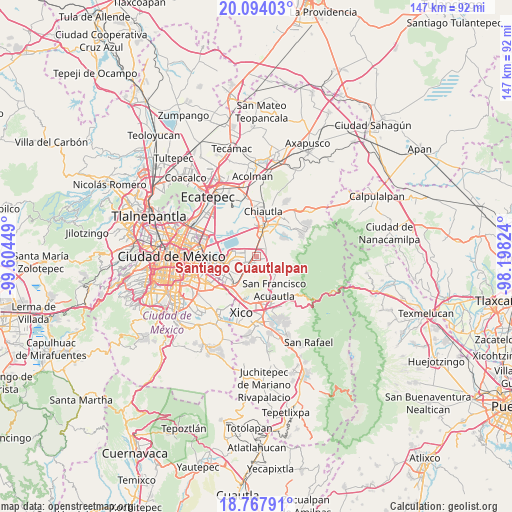
Santiago Cuautlalpan GPS coordinates[2]
19° 25' 56.352" North, 98° 54' 4.896" West
| Map corner | latitude | longitude |
|---|---|---|
| Upper-left | 20.09403°, | -99.60449° |
| Center: | 19.43232°, | -98.90136° |
| Lower-right: | 18.76791°, | -98.19824° |
| Map W x H: | 147.5×147.5 km | = 91.7×91.7mi |
| max Lat: | 32.7° ⇑55.5% North |
| Santiago Cuautlalpan: | 19.43232° |
| min Lat: | ⇓44.5% South 14.53588° |
| min Long | Santiago Cuautl | max Long |
| -117.105° | -98.90136° | -86.73105° |
| W 51.9%⇐ | ⇒48.1% E |
Elevation
Elevation of Santiago Cuautlalpan is 2254 m = 7395 ft, and this is 1000.3 m = 3282 ft above average elevation for this country.
| Max E: |
3497 m = 11473 ft | 15.3% |
| Santiago Cuautlalpan | 2254 m 7395 ft | |
| Avg. | 1253.7 m = 4113 ft | |
Min E: |
-1 m = -3 ft | 84.7% |
See also: Mexico elevation on elevation.city.
Geographical zone
Santiago Cuautlalpan is located in North Torrid zone (between Equator and Tropic of Cancer). Distance of this Northern Tropic circle is 445.2 km =276.6 mi to North.| Distance of | km | miles | from Santiago Cuautlalpan |
|---|---|---|---|
| North Pole | 7846.4 | 4875.5 | to North |
| Arctic Circle | 5240.5 | 3256.3 | to North |
| Tropic Cancer | 445.2 | 276.6 | to North |
| Equator | 2160.7 | 1342.6 | to South |


Nearby cities:
15 places around Santiago Cuautlalpan: (largest is in red/bold)
• Arenal
7.2 km =4.5 mi,  217°
217°
• Chicoloapan
1.7 km =1.1 mi,  182°
182°
• Colonia Guadalupe Victoria
7.7 km =4.8 mi,  345°
345°
• Colonia Lázaro Cárdenas
1.6 km =1 mi, 347°
• Colonia Villas de Tolimpa
5.1 km =3.2 mi,  21°
21°
• Colonia las Tijeras
4.7 km =2.9 mi,  44°
44°
• Ejido la Venta Cuautlalpan
3.2 km =2 mi,  116°
116°
• Ejidos de Beltrán Cuautlalpan
3.2 km =2 mi,  322°
322°
• Lomas de San Sebastián
6.5 km =4 mi,  210°
210°
• Montecillo
2.9 km =1.8 mi, 345°
• Rancho la Cabaña
0.8 km =0.5 mi,  145°
145°
• San Bernardino
5 km =3.1 mi,  6°
6°
• San Miguel Coatlinchán
3.6 km =2.2 mi,  56°
56°
• Santa Martha
1.7 km =1.1 mi,  266°
266°
• Santa María Chimalhuacán
5.3 km =3.3 mi,  256°
256°
Sources, notices
• [Note1] Compared only with cities in Mexico existing in our database
• [Src1] Map data: © OpenStreetMap contributors (CC-BY-SA)
• [Src2] Other city data from geonames.org with taken over terms of usage.
• [Src3] Geographical zone / Annual Mean Temperature by Robert A. Rohde @ Wikipedia
