Los Reyes geodata
Los Reyes (State of Mexico) is a populated place; located in Mexico in America/Mexico_City (GMT-6) time zone. With population of 4,012 people, there are 2271 cities with bigger population in this country. Compared to other cities in Mexico, 50% of cities are located further ↓South; 61% of cities are located further →East and 96% of cities have lower elevation than Los Reyes. Note1


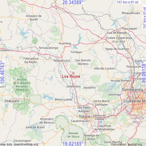
Los Reyes GPS coordinates[2]
19° 41' 6.864" North, 99° 45' 52.2" West
| Map corner | latitude | longitude |
|---|---|---|
| Upper-left | 20.34589°, | -100.46763° |
| Center: | 19.68524°, | -99.7645° |
| Lower-right: | 19.02185°, | -99.06138° |
| Map W x H: | 147.2×147.2 km | = 91.5×91.5mi |
| max Lat: | 32.7° ⇑50% North |
| Los Reyes: | 19.68524° |
| min Lat: | ⇓50% South 14.53588° |
| min Long | Los Reyes | max Long |
| -117.105° | -99.7645° | -86.73105° |
| W 39%⇐ | ⇒61% E |
Elevation
Elevation of Los Reyes is 2628 m = 8622 ft, and this is 1374.3 m = 4509 ft above average elevation for this country.
| Max E: |
3497 m = 11473 ft | 4% |
| Los Reyes | 2628 m 8622 ft | |
| Avg. | 1253.7 m = 4113 ft | |
Min E: |
-1 m = -3 ft | 96% |
See also: Mexico elevation on elevation.city.
Geographical zone
Los Reyes is located in North Torrid zone (between Equator and Tropic of Cancer). Distance of this Northern Tropic circle is 417.1 km =259.2 mi to North.| Distance of | km | miles | from Los Reyes |
|---|---|---|---|
| North Pole | 7818.3 | 4858.1 | to North |
| Arctic Circle | 5212.4 | 3238.8 | to North |
| Tropic Cancer | 417.1 | 259.2 | to North |
| Equator | 2188.8 | 1360.1 | to South |


Nearby cities:
15 places around Los Reyes: (largest is in red/bold)
• Barrio de Guadalupe
5.3 km =3.3 mi,  264°
264°
• Barrio de San Joaquín
4.8 km =3 mi,  253°
253°
• Barrio de Trojes
5.9 km =3.7 mi,  171°
171°
• Barrio de la Luz
6.1 km =3.8 mi,  58°
58°
• Barrio la Tenería
3 km =1.9 mi,  287°
287°
• El Progreso
1.6 km =1 mi,  325°
325°
• Huemetla
4.5 km =2.8 mi,  42°
42°
• Jocotitlán
3.7 km =2.3 mi,  317°
317°
• La Providencia
1.9 km =1.2 mi,  31°
31°
• Mavoro
6.4 km =4 mi, 289°
• Meje
6.9 km =4.3 mi,  82°
82°
• San Francisco Chejé
1.7 km =1.1 mi,  107°
107°
• San José Boqui
4.2 km =2.6 mi, 64°
• Santiago Yeché
6.1 km =3.8 mi, 64°
• Tiacaque
5.5 km =3.4 mi,  104°
104°
Sources, notices
• [Note1] Compared only with cities in Mexico existing in our database
• [Src1] Map data: © OpenStreetMap contributors (CC-BY-SA)
• [Src2] Other city data from geonames.org with taken over terms of usage.
• [Src3] Geographical zone / Annual Mean Temperature by Robert A. Rohde @ Wikipedia
