Jocotitlán geodata
Jocotitlán (State of Mexico) is a seat of a second-order administrative division; located in Mexico in America/Mexico_City (GMT-6) time zone. With population of 7,575 people, there are 1228 cities with bigger population in this country. Compared to other cities in Mexico, 50.7% of cities are located further ↓South; 61.3% of cities are located further →East and 96.7% of cities have lower elevation than Jocotitlán. Note1


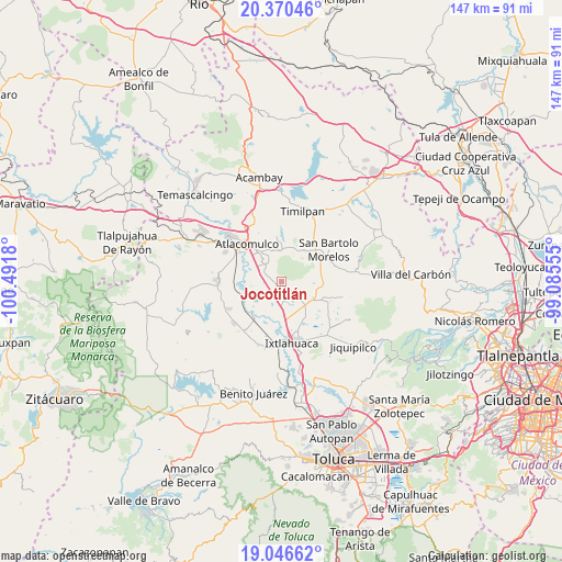
Jocotitlán GPS coordinates[2]
19° 42' 35.676" North, 99° 47' 19.212" West
| Map corner | latitude | longitude |
|---|---|---|
| Upper-left | 20.37046°, | -100.4918° |
| Center: | 19.70991°, | -99.78867° |
| Lower-right: | 19.04662°, | -99.08555° |
| Map W x H: | 147.2×147.2 km | = 91.5×91.5mi |
| max Lat: | 32.7° ⇑49.3% North |
| Jocotitlán: | 19.70991° |
| min Lat: | ⇓50.7% South 14.53588° |
| min Long | Jocotitlán | max Long |
| -117.105° | -99.78867° | -86.73105° |
| W 38.7%⇐ | ⇒61.3% E |
Elevation
Elevation of Jocotitlán is 2666 m = 8747 ft, and this is 1412.3 m = 4634 ft above average elevation for this country.
| Max E: |
3497 m = 11473 ft | 3.3% |
| Jocotitlán | 2666 m 8747 ft | |
| Avg. | 1253.7 m = 4113 ft | |
Min E: |
-1 m = -3 ft | 96.7% |
See also: Mexico elevation on elevation.city.
Geographical zone
Jocotitlán is located in North Torrid zone (between Equator and Tropic of Cancer). Distance of this Northern Tropic circle is 414.4 km =257.5 mi to North.| Distance of | km | miles | from Jocotitlán |
|---|---|---|---|
| North Pole | 7815.5 | 4856.3 | to North |
| Arctic Circle | 5209.6 | 3237.1 | to North |
| Tropic Cancer | 414.4 | 257.5 | to North |
| Equator | 2191.5 | 1361.7 | to South |


Nearby cities:
15 places around Jocotitlán: (largest is in red/bold)
• Barrio de Guadalupe
4.3 km =2.7 mi,  220°
220°
• Barrio de San Joaquín
4.6 km =2.9 mi,  206°
206°
• Barrio el Ruso
4.1 km =2.5 mi,  274°
274°
• Barrio la Tenería
1.8 km =1.1 mi,  190°
190°
• El Progreso
2.1 km =1.3 mi,  131°
131°
• Huemetla
5.6 km =3.5 mi,  84°
84°
• La Loma de Endare
4.6 km =2.9 mi,  302°
302°
• La Providencia
3.7 km =2.3 mi,  107°
107°
• Los Reyes
3.7 km =2.3 mi,  137°
137°
• Mavoro
3.6 km =2.2 mi,  259°
259°
• Ojo de Agua
6 km =3.7 mi,  290°
290°
• San Antonio Enchisi
5.8 km =3.6 mi,  329°
329°
• San Francisco Chejé
5.3 km =3.3 mi, 128°
• San José Boqui
6.4 km =4 mi,  98°
98°
• Santa María Endare
3.3 km =2.1 mi, 301°
Sources, notices
• [Note1] Compared only with cities in Mexico existing in our database
• [Src1] Map data: © OpenStreetMap contributors (CC-BY-SA)
• [Src2] Other city data from geonames.org with taken over terms of usage.
• [Src3] Geographical zone / Annual Mean Temperature by Robert A. Rohde @ Wikipedia
