Los Limones geodata
Los Limones (Morelos) is a populated place; located in Mexico in America/Mexico_City (GMT-6) time zone. With population of 561 people, there are 15205 cities with bigger population in this country. Compared to other cities in Mexico, 68.9% of cities are located further ↑North; 52.9% of cities are located further ←West and 51% of cities have lower elevation than Los Limones. Note1


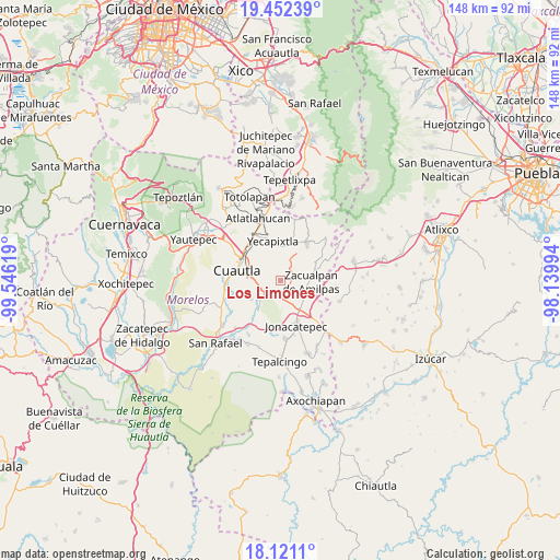
Los Limones GPS coordinates[2]
18° 47' 17.016" North, 98° 50' 35.016" West
| Map corner | latitude | longitude |
|---|---|---|
| Upper-left | 19.45239°, | -99.54619° |
| Center: | 18.78806°, | -98.84306° |
| Lower-right: | 18.1211°, | -98.13994° |
| Map W x H: | 148×148 km | = 92×92mi |
| max Lat: | 32.7° ⇑68.9% North |
| Los Limones: | 18.78806° |
| min Lat: | ⇓31.1% South 14.53588° |
| min Long | Los Limones | max Long |
| -117.105° | -98.84306° | -86.73105° |
| W 52.9%⇐ | ⇒47.1% E |
Elevation
Elevation of Los Limones is 1483 m = 4865 ft, and this is 229.3 m = 752 ft above average elevation for this country.
| Max E: |
3497 m = 11473 ft | 49% |
| Los Limones | 1483 m 4865 ft | |
| Avg. | 1253.7 m = 4113 ft | |
Min E: |
-1 m = -3 ft | 51% |
See also: Mexico elevation on elevation.city.
Geographical zone
Los Limones is located in North Torrid zone (between Equator and Tropic of Cancer). Distance of this Northern Tropic circle is 516.9 km =321.2 mi to North.| Distance of | km | miles | from Los Limones |
|---|---|---|---|
| North Pole | 7918 | 4920 | to North |
| Arctic Circle | 5312.1 | 3300.8 | to North |
| Tropic Cancer | 516.9 | 321.2 | to North |
| Equator | 2089 | 1298 | to South |


Nearby cities:
15 places around Los Limones: (largest is in red/bold)
• Amayuca
8.5 km =5.3 mi,  146°
146°
• Empleado Municipal
6.8 km =4.2 mi,  267°
267°
• Fraccionamiento Huertas de Cuautla
7.8 km =4.8 mi,  250°
250°
• Fraccionamiento las Llaves
3.1 km =1.9 mi,  194°
194°
• Huazulco
8.1 km =5 mi,  118°
118°
• Huexca
3.3 km =2.1 mi,  303°
303°
• Juan Morales
8.7 km =5.4 mi,  287°
287°
• Loma Bonita
8.2 km =5.1 mi, 290°
• Mixtlalcingo
6.3 km =3.9 mi, 285°
• Popotlán (Barrio Santo Tomás)
8.6 km =5.3 mi,  107°
107°
• Tecajec
3.2 km =2 mi,  69°
69°
• Temoac
7.1 km =4.4 mi,  104°
104°
• Unidad Habitacional 10 de Abril
8.6 km =5.3 mi,  244°
244°
• Unidad Habitacional Mariano Matamoros
4.6 km =2.9 mi, 192°
• Zacualpan de Amilpas
8.1 km =5 mi,  93°
93°
Sources, notices
• [Note1] Compared only with cities in Mexico existing in our database
• [Src1] Map data: © OpenStreetMap contributors (CC-BY-SA)
• [Src2] Other city data from geonames.org with taken over terms of usage.
• [Src3] Geographical zone / Annual Mean Temperature by Robert A. Rohde @ Wikipedia
