Amayuca geodata
Amayuca (Morelos) is a populated place; located in Mexico in America/Mexico_City (GMT-6) time zone. With population of 5,287 people, there are 1749 cities with bigger population in this country. Compared to other cities in Mexico, 70% of cities are located further ↑North; 53.7% of cities are located further ←West and 50.2% of cities have lower elevation than Amayuca. Note1


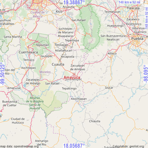
Amayuca GPS coordinates[2]
18° 43' 26.688" North, 98° 47' 53.232" West
| Map corner | latitude | longitude |
|---|---|---|
| Upper-left | 19.38867°, | -99.50125° |
| Center: | 18.72408°, | -98.79812° |
| Lower-right: | 18.05687°, | -98.095° |
| Map W x H: | 148.1×148.1 km | = 92×92mi |
| max Lat: | 32.7° ⇑70% North |
| Amayuca: | 18.72408° |
| min Lat: | ⇓30% South 14.53588° |
| min Long | Amayuca | max Long |
| -117.105° | -98.79812° | -86.73105° |
| W 53.7%⇐ | ⇒46.3% E |
Elevation
Elevation of Amayuca is 1442 m = 4731 ft, and this is 188.3 m = 618 ft above average elevation for this country.
| Max E: |
3497 m = 11473 ft | 49.8% |
| Amayuca | 1442 m 4731 ft | |
| Avg. | 1253.7 m = 4113 ft | |
Min E: |
-1 m = -3 ft | 50.2% |
See also: Mexico elevation on elevation.city.
Geographical zone
Amayuca is located in North Torrid zone (between Equator and Tropic of Cancer). Distance of this Northern Tropic circle is 524 km =325.6 mi to North.| Distance of | km | miles | from Amayuca |
|---|---|---|---|
| North Pole | 7925.1 | 4924.4 | to North |
| Arctic Circle | 5319.3 | 3305.3 | to North |
| Tropic Cancer | 524 | 325.6 | to North |
| Equator | 2081.9 | 1293.6 | to South |


Nearby cities:
15 places around Amayuca: (largest is in red/bold)
• Acteopan
9.9 km =6.2 mi,  63°
63°
• Amacuitlapilco
3.4 km =2.1 mi,  204°
204°
• Amilcingo
3.5 km =2.2 mi,  54°
54°
• Atotonilco
9 km =5.6 mi, 202°
• Chalcatzingo
4.6 km =2.9 mi,  146°
146°
• Fraccionamiento las Llaves
6.9 km =4.3 mi,  306°
306°
• Huazulco
4 km =2.5 mi,  36°
36°
• Jantetelco
2.3 km =1.4 mi,  106°
106°
• Jonacatepec
4.8 km =3 mi,  186°
186°
• Los Limones
8.5 km =5.3 mi,  326°
326°
• Popotlán (Barrio Santo Tomás)
5.7 km =3.5 mi, 37°
• Tecajec
8.4 km =5.2 mi,  347°
347°
• Temoac
5.8 km =3.6 mi,  22°
22°
• Unidad Habitacional Mariano Matamoros
6.3 km =3.9 mi,  294°
294°
• Zacualpan de Amilpas
7.5 km =4.7 mi,  27°
27°
Sources, notices
• [Note1] Compared only with cities in Mexico existing in our database
• [Src1] Map data: © OpenStreetMap contributors (CC-BY-SA)
• [Src2] Other city data from geonames.org with taken over terms of usage.
• [Src3] Geographical zone / Annual Mean Temperature by Robert A. Rohde @ Wikipedia
