Congregación Reforma geodata
Congregación Reforma (Chiapas) is a populated place; located in Mexico in America/Mexico_City (GMT-6) time zone. With population of 1,132 people, there are 7659 cities with bigger population in this country. Compared to other cities in Mexico, 99.9% of cities are located further ↑North; 93.3% of cities are located further ←West and 85% of cities have higher elevation than Congregación Reforma. Note1
Current local time in Congregación Reforma:
08:34 AM, WednesdayDifference from your time zone: hours


Congregación Reforma GPS coordinates[2]
14° 46' 55.488" North, 92° 18' 51.264" West
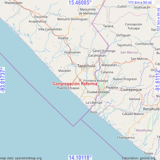
| Map corner | latitude | longitude |
|---|---|---|
| Upper-left | 15.46085°, | -93.01737° |
| Center: | 14.78208°, | -92.31424° |
| Lower-right: | 14.10118°, | -91.61112° |
| Map W x H: | 151.2×151.2 km | = 94×94mi |
| max Lat: | 32.7° ⇑99.9% North |
| Congregación Reforma: | 14.78208° |
| min Lat: | ⇓0.1% South 14.53588° |
| min Long | Congregación R | max Long |
| -117.105° | -92.31424° | -86.73105° |
| W 93.3%⇐ | ⇒6.7% E |
Elevation
Elevation of Congregación Reforma is 44 m = 144 ft, and this is 1209.7 m = 3969 ft below average elevation for this country.
| Max E: |
3497 m = 11473 ft | 85% |
| Avg. | 1253.7 m = 4113 ft | |
| Congregación Reforma | 44 m = 144 ft | |
Min E: |
-1 m = -3 ft | 15% |
See also: Mexico elevation on elevation.city.
Geographical zone
Congregación Reforma is located in North Torrid zone (between Equator and Tropic of Cancer). Distance of this Northern Tropic circle is 962.3 km =597.9 mi to North.| Distance of | km | miles | from Congregación Reforma |
|---|---|---|---|
| North Pole | 8363.4 | 5196.8 | to North |
| Arctic Circle | 5757.6 | 3577.6 | to North |
| Tropic Cancer | 962.3 | 597.9 | to North |
| Equator | 1643.6 | 1021.3 | to South |


Nearby cities:
15 places around Congregación Reforma: (largest is in red/bold)
• Cebadilla 1ra. Sección
9.8 km =6.1 mi,  22°
22°
• Cebadilla 2da. Sección
4.3 km =2.7 mi,  11°
11°
• Guadalupe Victoria
7.2 km =4.5 mi,  70°
70°
• Joaquín Miguel Gutiérrez (El Manzano)
2.7 km =1.7 mi,  148°
148°
• Leoncillos
10 km =6.2 mi,  260°
260°
• Llano de la Lima
9.5 km =5.9 mi, 11°
• Los Cafetales
9.6 km =6 mi, 7°
• Murillo
4.3 km =2.7 mi,  29°
29°
• Octavio Paz
10 km =6.2 mi, 32°
• Raymundo Enríquez
9.5 km =5.9 mi,  359°
359°
• Río Florido
8.6 km =5.3 mi,  340°
340°
• San Cristóbal Buenavista
6.9 km =4.3 mi,  287°
287°
• Tinajas 1ra. Sección
7.3 km =4.5 mi,  192°
192°
• Tinajas 3ra. Sección
4.9 km =3 mi,  251°
251°
• Vida Mejor I
9.8 km =6.1 mi,  4°
4°
Sources, notices
• [Note1] Compared only with cities in Mexico existing in our database
• [Src1] Map data: © OpenStreetMap contributors (CC-BY-SA)
• [Src2] Other city data from geonames.org with taken over terms of usage.
• [Src3] Geographical zone / Annual Mean Temperature by Robert A. Rohde @ Wikipedia
