Guadalupe Victoria geodata
Guadalupe Victoria (Chiapas) is a populated place; located in Mexico in America/Mexico_City (GMT-6) time zone. With population of 1,251 people, there are 6933 cities with bigger population in this country. Compared to other cities in Mexico, 99.8% of cities are located further ↑North; 93.8% of cities are located further ←West and 82.2% of cities have higher elevation than Guadalupe Victoria. Note1


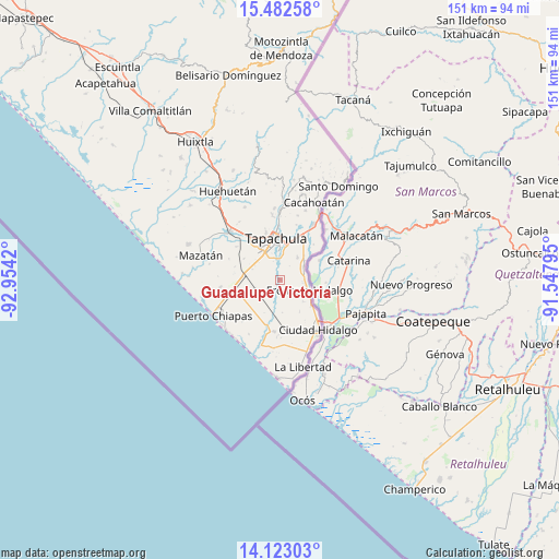
Guadalupe Victoria GPS coordinates[2]
14° 48' 13.932" North, 92° 15' 3.852" West
| Map corner | latitude | longitude |
|---|---|---|
| Upper-left | 15.48258°, | -92.9542° |
| Center: | 14.80387°, | -92.25107° |
| Lower-right: | 14.12303°, | -91.54795° |
| Map W x H: | 151.2×151.2 km | = 94×94mi |
| max Lat: | 32.7° ⇑99.8% North |
| Guadalupe Victoria: | 14.80387° |
| min Lat: | ⇓0.2% South 14.53588° |
| min Long | Guadalupe Victo | max Long |
| -117.105° | -92.25107° | -86.73105° |
| W 93.8%⇐ | ⇒6.2% E |
Elevation
Elevation of Guadalupe Victoria is 68 m = 223 ft, and this is 1185.7 m = 3890 ft below average elevation for this country.
| Max E: |
3497 m = 11473 ft | 82.2% |
| Avg. | 1253.7 m = 4113 ft | |
| Guadalupe Victoria | 68 m = 223 ft | |
Min E: |
-1 m = -3 ft | 17.8% |
See also: Mexico elevation on elevation.city.
Geographical zone
Guadalupe Victoria is located in North Torrid zone (between Equator and Tropic of Cancer). Distance of this Northern Tropic circle is 959.9 km =596.5 mi to North.| Distance of | km | miles | from Guadalupe Victoria |
|---|---|---|---|
| North Pole | 8361 | 5195.3 | to North |
| Arctic Circle | 5755.1 | 3576.1 | to North |
| Tropic Cancer | 959.9 | 596.5 | to North |
| Equator | 1646 | 1022.8 | to South |


Nearby cities:
15 places around Guadalupe Victoria: (largest is in red/bold)
• Cacahoatales
5.1 km =3.2 mi,  87°
87°
• Cebadilla 1ra. Sección
7.3 km =4.5 mi,  335°
335°
• Cebadilla 2da. Sección
6.2 km =3.9 mi,  286°
286°
• Congregación Reforma
7.2 km =4.5 mi,  250°
250°
• El Arenal
6.8 km =4.2 mi,  84°
84°
• Joaquín Miguel Gutiérrez (El Manzano)
7.2 km =4.5 mi,  229°
229°
• La Joya
6.7 km =4.2 mi,  355°
355°
• Las Palmeras
7.5 km =4.7 mi, 339°
• Los Palacios
6 km =3.7 mi,  352°
352°
• Metapa
7.3 km =4.5 mi,  60°
60°
• Murillo
4.9 km =3 mi, 285°
• Octavio Paz
6.2 km =3.9 mi, 347°
• Omoa
3.8 km =2.4 mi,  31°
31°
• Texcaltic
6.9 km =4.3 mi,  97°
97°
• Vicente Guerrero
7.6 km =4.7 mi,  39°
39°
Sources, notices
• [Note1] Compared only with cities in Mexico existing in our database
• [Src1] Map data: © OpenStreetMap contributors (CC-BY-SA)
• [Src2] Other city data from geonames.org with taken over terms of usage.
• [Src3] Geographical zone / Annual Mean Temperature by Robert A. Rohde @ Wikipedia
