Murillo geodata
Murillo (Chiapas) is a populated place; located in Mexico in America/Mexico_City (GMT-6) time zone. With population of 764 people, there are 11465 cities with bigger population in this country. Compared to other cities in Mexico, 99.8% of cities are located further ↑North; 93.4% of cities are located further ←West and 82.6% of cities have higher elevation than Murillo. Note1


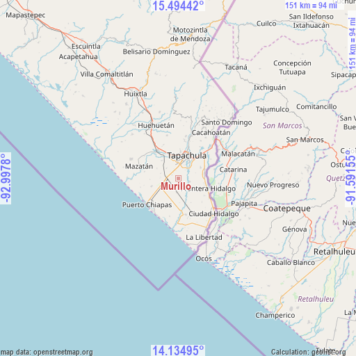
Murillo GPS coordinates[2]
14° 48' 56.7" North, 92° 17' 40.812" West
| Map corner | latitude | longitude |
|---|---|---|
| Upper-left | 15.49442°, | -92.9978° |
| Center: | 14.81575°, | -92.29467° |
| Lower-right: | 14.13495°, | -91.59155° |
| Map W x H: | 151.2×151.2 km | = 94×94mi |
| max Lat: | 32.7° ⇑99.8% North |
| Murillo: | 14.81575° |
| min Lat: | ⇓0.2% South 14.53588° |
| min Long | Murillo | max Long |
| -117.105° | -92.29467° | -86.73105° |
| W 93.4%⇐ | ⇒6.6% E |
Elevation
Elevation of Murillo is 64 m = 210 ft, and this is 1189.7 m = 3903 ft below average elevation for this country.
| Max E: |
3497 m = 11473 ft | 82.6% |
| Avg. | 1253.7 m = 4113 ft | |
| Murillo | 64 m = 210 ft | |
Min E: |
-1 m = -3 ft | 17.4% |
See also: Mexico elevation on elevation.city.
Geographical zone
Murillo is located in North Torrid zone (between Equator and Tropic of Cancer). Distance of this Northern Tropic circle is 958.6 km =595.6 mi to North.| Distance of | km | miles | from Murillo |
|---|---|---|---|
| North Pole | 8359.7 | 5194.5 | to North |
| Arctic Circle | 5753.8 | 3575.2 | to North |
| Tropic Cancer | 958.6 | 595.6 | to North |
| Equator | 1647.4 | 1023.6 | to South |


Nearby cities:
15 places around Murillo: (largest is in red/bold)
• Cebadilla 1ra. Sección
5.6 km =3.5 mi,  16°
16°
• Cebadilla 2da. Sección
1.3 km =0.8 mi,  288°
288°
• Congregación Reforma
4.3 km =2.7 mi,  209°
209°
• Guadalupe Victoria
4.9 km =3 mi,  105°
105°
• Joaquín Miguel Gutiérrez (El Manzano)
6.1 km =3.8 mi,  186°
186°
• La Joya
6.8 km =4.2 mi,  37°
37°
• Las Palmeras
6.1 km =3.8 mi, 19°
• Llano de la Lima
5.6 km =3.5 mi,  357°
357°
• Los Cafetales
5.8 km =3.6 mi,  352°
352°
• Los Palacios
6 km =3.7 mi, 40°
• Octavio Paz
5.7 km =3.5 mi, 35°
• Omoa
6.9 km =4.3 mi,  73°
73°
• Raymundo Enríquez
6.1 km =3.8 mi,  339°
339°
• Río Florido
6.7 km =4.2 mi,  310°
310°
• Vida Mejor I
6.2 km =3.9 mi, 346°
Sources, notices
• [Note1] Compared only with cities in Mexico existing in our database
• [Src1] Map data: © OpenStreetMap contributors (CC-BY-SA)
• [Src2] Other city data from geonames.org with taken over terms of usage.
• [Src3] Geographical zone / Annual Mean Temperature by Robert A. Rohde @ Wikipedia
