La Palma geodata
La Palma (Chiapas) is a populated place; located in Mexico in America/Mexico_City (GMT-6) time zone. With population of 678 people, there are 12811 cities with bigger population in this country. Compared to other cities in Mexico, 99% of cities are located further ↑North; 89.6% of cities are located further ←West and 99.3% of cities have higher elevation than La Palma. Note1


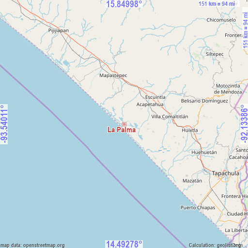
La Palma GPS coordinates[2]
15° 10' 20.892" North, 92° 50' 13.128" West
| Map corner | latitude | longitude |
|---|---|---|
| Upper-left | 15.84998°, | -93.54011° |
| Center: | 15.17247°, | -92.83698° |
| Lower-right: | 14.49278°, | -92.13386° |
| Map W x H: | 150.9×150.9 km | = 93.8×93.8mi |
| max Lat: | 32.7° ⇑99% North |
| La Palma: | 15.17247° |
| min Lat: | ⇓1% South 14.53588° |
| min Long | La Palma | max Long |
| -117.105° | -92.83698° | -86.73105° |
| W 89.6%⇐ | ⇒10.4% E |
Elevation
Elevation of La Palma is 5 m = 16 ft, and this is 1248.7 m = 4097 ft below average elevation for this country.
| Max E: |
3497 m = 11473 ft | 99.3% |
| Avg. | 1253.7 m = 4113 ft | |
| La Palma | 5 m = 16 ft | |
Min E: |
-1 m = -3 ft | 0.7% |
See also: Mexico elevation on elevation.city.
Geographical zone
La Palma is located in North Torrid zone (between Equator and Tropic of Cancer). Distance of this Northern Tropic circle is 918.9 km =571 mi to North.| Distance of | km | miles | from La Palma |
|---|---|---|---|
| North Pole | 8320 | 5169.8 | to North |
| Arctic Circle | 5714.2 | 3550.6 | to North |
| Tropic Cancer | 918.9 | 571 | to North |
| Equator | 1687 | 1048.3 | to South |


Nearby cities:
15 places around La Palma: (largest is in red/bold)
• Acapetahua
19.9 km =12.4 mi,  52°
52°
• Barrio Nuevo
17.4 km =10.8 mi,  62°
62°
• Cantón el Progreso
20.4 km =12.7 mi,  99°
99°
• El Arenal
14.8 km =9.2 mi,  89°
89°
• El Madronal
18.6 km =11.6 mi, 48°
• Jiquilpan
17.2 km =10.7 mi,  11°
11°
• Jiquilpan (Estación Bonanza)
21.1 km =13.1 mi,  26°
26°
• Las Cruces
16.7 km =10.4 mi,  43°
43°
• Luis Espinoza
15.8 km =9.8 mi,  82°
82°
• Mariano Matamoros
13.9 km =8.6 mi, 48°
• Nicolás Bravo Dos Anexo Emiliano Zapata
18.1 km =11.2 mi,  356°
356°
• Río Arriba Salvación
14.8 km =9.2 mi, 101°
• Soconusco
19.8 km =12.3 mi, 36°
• Teziutlán
20.1 km =12.5 mi, 83°
• Veinte de Abril
12.5 km =7.8 mi,  21°
21°
Sources, notices
• [Note1] Compared only with cities in Mexico existing in our database
• [Src1] Map data: © OpenStreetMap contributors (CC-BY-SA)
• [Src2] Other city data from geonames.org with taken over terms of usage.
• [Src3] Geographical zone / Annual Mean Temperature by Robert A. Rohde @ Wikipedia
