La Lagunilla geodata
La Lagunilla (Hidalgo) is a populated place; located in Mexico in America/Mexico_City (GMT-6) time zone. With population of 1,538 people, there are 5618 cities with bigger population in this country. Compared to other cities in Mexico, 58.5% of cities are located further ↓South; 57.6% of cities are located further ←West and 91.8% of cities have lower elevation than La Lagunilla. Note1


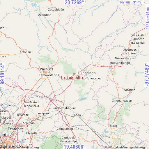
La Lagunilla GPS coordinates[2]
20° 4' 4.332" North, 98° 28' 40.836" West
| Map corner | latitude | longitude |
|---|---|---|
| Upper-left | 20.7269°, | -99.18114° |
| Center: | 20.06787°, | -98.47801° |
| Lower-right: | 19.40606°, | -97.77489° |
| Map W x H: | 146.9×146.9 km | = 91.3×91.3mi |
| max Lat: | 32.7° ⇑41.5% North |
| La Lagunilla: | 20.06787° |
| min Lat: | ⇓58.5% South 14.53588° |
| min Long | La Lagunilla | max Long |
| -117.105° | -98.47801° | -86.73105° |
| W 57.6%⇐ | ⇒42.4% E |
Elevation
Elevation of La Lagunilla is 2473 m = 8114 ft, and this is 1219.3 m = 4000 ft above average elevation for this country.
| Max E: |
3497 m = 11473 ft | 8.2% |
| La Lagunilla | 2473 m 8114 ft | |
| Avg. | 1253.7 m = 4113 ft | |
Min E: |
-1 m = -3 ft | 91.8% |
See also: Mexico elevation on elevation.city.
Geographical zone
La Lagunilla is located in North Torrid zone (between Equator and Tropic of Cancer). Distance of this Northern Tropic circle is 374.6 km =232.8 mi to North.| Distance of | km | miles | from La Lagunilla |
|---|---|---|---|
| North Pole | 7775.7 | 4831.6 | to North |
| Arctic Circle | 5169.8 | 3212.4 | to North |
| Tropic Cancer | 374.6 | 232.8 | to North |
| Equator | 2231.3 | 1386.5 | to South |


Nearby cities:
15 places around La Lagunilla: (largest is in red/bold)
• Ahuehuetitla
6.7 km =4.2 mi,  73°
73°
• Colonia Agustín Olvera
7.6 km =4.7 mi,  36°
36°
• Colonia Chauténco
7.5 km =4.7 mi,  23°
23°
• Colonia Felipe Ángeles
6.4 km =4 mi,  103°
103°
• El Susto
1.9 km =1.2 mi,  237°
237°
• Emiliano Zapata
7.4 km =4.6 mi,  81°
81°
• Fraccionamiento Carlos Salinas de Gortari
6.9 km =4.3 mi,  46°
46°
• Fraccionamiento del Magisterio Tulancinguense
8.2 km =5.1 mi, 83°
• Javier Rojo Gómez
6.3 km =3.9 mi,  88°
88°
• Los Romeros
7.8 km =4.8 mi,  122°
122°
• Paxtepec
5.2 km =3.2 mi,  109°
109°
• Pedregal de San Francisco
7.8 km =4.8 mi, 91°
• Pedregal de San José
7.4 km =4.6 mi, 91°
• Segundas Lajas
2.1 km =1.3 mi,  162°
162°
• Unidades Habitacionales
6 km =3.7 mi, 94°
Sources, notices
• [Note1] Compared only with cities in Mexico existing in our database
• [Src1] Map data: © OpenStreetMap contributors (CC-BY-SA)
• [Src2] Other city data from geonames.org with taken over terms of usage.
• [Src3] Geographical zone / Annual Mean Temperature by Robert A. Rohde @ Wikipedia
