Jopala geodata
Jopala (Puebla) is a populated place; located in Mexico in America/Mexico_City (GMT-6) time zone. With population of 1,789 people, there are 4860 cities with bigger population in this country. Compared to other cities in Mexico, 60.6% of cities are located further ↓South; 67.3% of cities are located further ←West and 65.8% of cities have higher elevation than Jopala. Note1


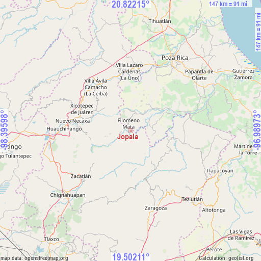
Jopala GPS coordinates[2]
20° 9' 48.708" North, 97° 41' 34.26" West
| Map corner | latitude | longitude |
|---|---|---|
| Upper-left | 20.82215°, | -98.39598° |
| Center: | 20.16353°, | -97.69285° |
| Lower-right: | 19.50211°, | -96.98973° |
| Map W x H: | 146.8×146.8 km | = 91.2×91.2mi |
| max Lat: | 32.7° ⇑39.4% North |
| Jopala: | 20.16353° |
| min Lat: | ⇓60.6% South 14.53588° |
| min Long | Jopala | max Long |
| -117.105° | -97.69285° | -86.73105° |
| W 67.3%⇐ | ⇒32.7% E |
Elevation
Elevation of Jopala is 646 m = 2119 ft, and this is 607.7 m = 1994 ft below average elevation for this country.
| Max E: |
3497 m = 11473 ft | 65.8% |
| Avg. | 1253.7 m = 4113 ft | |
| Jopala | 646 m = 2119 ft | |
Min E: |
-1 m = -3 ft | 34.2% |
See also: Mexico elevation on elevation.city.
Geographical zone
Jopala is located in North Torrid zone (between Equator and Tropic of Cancer). Distance of this Northern Tropic circle is 363.9 km =226.1 mi to North.| Distance of | km | miles | from Jopala |
|---|---|---|---|
| North Pole | 7765.1 | 4825 | to North |
| Arctic Circle | 5159.2 | 3205.8 | to North |
| Tropic Cancer | 363.9 | 226.1 | to North |
| Equator | 2242 | 1393.1 | to South |


Nearby cities:
15 places around Jopala: (largest is in red/bold)
• Buenos Aires
5.9 km =3.7 mi,  258°
258°
• Bugambilias (La Cruz)
1.2 km =0.7 mi,  337°
337°
• Dimas López
5.9 km =3.7 mi,  93°
93°
• El Crucero
6.1 km =3.8 mi,  351°
351°
• Filomeno Mata
4.2 km =2.6 mi, 344°
• Francisco Osorno
3.1 km =1.9 mi,  229°
229°
• Francisco Villa
5 km =3.1 mi,  69°
69°
• Ignacio Ramírez
7 km =4.3 mi,  214°
214°
• La Cruz
4.7 km =2.9 mi,  29°
29°
• Lacapan Camallagne
5.7 km =3.5 mi,  133°
133°
• Mecatlán
5.3 km =3.3 mi,  12°
12°
• Olintla
6.9 km =4.3 mi,  172°
172°
• Pumacachocochuchut
7.1 km =4.4 mi,  137°
137°
• Santa Catarina
4.5 km =2.8 mi,  118°
118°
• Vicente Guerrero
6 km =3.7 mi, 137°
Sources, notices
• [Note1] Compared only with cities in Mexico existing in our database
• [Src1] Map data: © OpenStreetMap contributors (CC-BY-SA)
• [Src2] Other city data from geonames.org with taken over terms of usage.
• [Src3] Geographical zone / Annual Mean Temperature by Robert A. Rohde @ Wikipedia
