Lacapan Camallagne geodata
Lacapan Camallagne (Puebla) is a populated place; located in Mexico in America/Mexico_City (GMT-6) time zone. With population of 1,120 people, there are 7751 cities with bigger population in this country. Compared to other cities in Mexico, 59.7% of cities are located further ↓South; 67.9% of cities are located further ←West and 67.9% of cities have higher elevation than Lacapan Camallagne. Note1


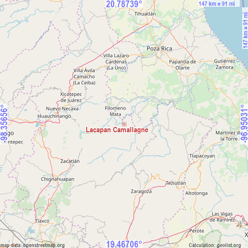
Lacapan Camallagne GPS coordinates[2]
20° 7' 43.032" North, 97° 39' 12.348" West
| Map corner | latitude | longitude |
|---|---|---|
| Upper-left | 20.78739°, | -98.35656° |
| Center: | 20.12862°, | -97.65343° |
| Lower-right: | 19.46706°, | -96.95031° |
| Map W x H: | 146.8×146.8 km | = 91.2×91.2mi |
| max Lat: | 32.7° ⇑40.3% North |
| Lacapan Camallagne: | 20.12862° |
| min Lat: | ⇓59.7% South 14.53588° |
| min Long | Lacapan Camalla | max Long |
| -117.105° | -97.65343° | -86.73105° |
| W 67.9%⇐ | ⇒32.1% E |
Elevation
Elevation of Lacapan Camallagne is 535 m = 1755 ft, and this is 718.7 m = 2358 ft below average elevation for this country.
| Max E: |
3497 m = 11473 ft | 67.9% |
| Avg. | 1253.7 m = 4113 ft | |
| Lacapan Camallagne | 535 m = 1755 ft | |
Min E: |
-1 m = -3 ft | 32.1% |
See also: Mexico elevation on elevation.city.
Geographical zone
Lacapan Camallagne is located in North Torrid zone (between Equator and Tropic of Cancer). Distance of this Northern Tropic circle is 367.8 km =228.5 mi to North.| Distance of | km | miles | from Lacapan Camallagne |
|---|---|---|---|
| North Pole | 7769 | 4827.4 | to North |
| Arctic Circle | 5163.1 | 3208.2 | to North |
| Tropic Cancer | 367.8 | 228.5 | to North |
| Equator | 2238.1 | 1390.7 | to South |


Nearby cities:
15 places around Lacapan Camallagne: (largest is in red/bold)
• Chilocoyo del Carmen
5.4 km =3.4 mi,  181°
181°
• Cinco de Mayo
2.5 km =1.6 mi,  82°
82°
• Dimas López
4 km =2.5 mi,  26°
26°
• Francisco Villa
5.7 km =3.5 mi,  5°
5°
• Huehuetla
3.9 km =2.4 mi,  130°
130°
• Kuwik Chuchut
4.8 km =3 mi,  112°
112°
• Leacaman
3.5 km =2.2 mi,  162°
162°
• Lipuntahuaca
4.8 km =3 mi,  149°
149°
• Olintla
4.4 km =2.7 mi,  227°
227°
• Pumacachocochuchut
1.5 km =0.9 mi, 155°
• Putaxcat
4.9 km =3 mi,  142°
142°
• Putlunichuchut (Vista Hermosa)
5 km =3.1 mi,  52°
52°
• Santa Catarina
1.7 km =1.1 mi,  353°
353°
• Vicente Guerrero
0.6 km =0.4 mi,  187°
187°
• Xonalpu
4.5 km =2.8 mi,  90°
90°
Sources, notices
• [Note1] Compared only with cities in Mexico existing in our database
• [Src1] Map data: © OpenStreetMap contributors (CC-BY-SA)
• [Src2] Other city data from geonames.org with taken over terms of usage.
• [Src3] Geographical zone / Annual Mean Temperature by Robert A. Rohde @ Wikipedia
