Hidalgo geodata
Hidalgo (Chiapas) is a populated place; located in Mexico in America/Mexico_City (GMT-6) time zone. With population of 697 people, there are 12494 cities with bigger population in this country. Compared to other cities in Mexico, 99.7% of cities are located further ↑North; 93% of cities are located further ←West and 83.8% of cities have higher elevation than Hidalgo. Note1


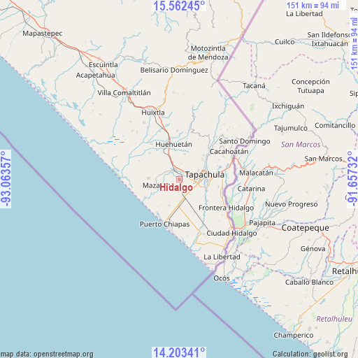
Hidalgo GPS coordinates[2]
14° 53' 2.4" North, 92° 21' 37.584" West
| Map corner | latitude | longitude |
|---|---|---|
| Upper-left | 15.56245°, | -93.06357° |
| Center: | 14.884°, | -92.36044° |
| Lower-right: | 14.20341°, | -91.65732° |
| Map W x H: | 151.1×151.1 km | = 93.9×93.9mi |
| max Lat: | 32.7° ⇑99.7% North |
| Hidalgo: | 14.884° |
| min Lat: | ⇓0.3% South 14.53588° |
| min Long | Hidalgo | max Long |
| -117.105° | -92.36044° | -86.73105° |
| W 93%⇐ | ⇒7% E |
Elevation
Elevation of Hidalgo is 53 m = 174 ft, and this is 1200.7 m = 3939 ft below average elevation for this country.
| Max E: |
3497 m = 11473 ft | 83.8% |
| Avg. | 1253.7 m = 4113 ft | |
| Hidalgo | 53 m = 174 ft | |
Min E: |
-1 m = -3 ft | 16.2% |
See also: Mexico elevation on elevation.city.
Geographical zone
Hidalgo is located in North Torrid zone (between Equator and Tropic of Cancer). Distance of this Northern Tropic circle is 951 km =590.9 mi to North.| Distance of | km | miles | from Hidalgo |
|---|---|---|---|
| North Pole | 8352.1 | 5189.8 | to North |
| Arctic Circle | 5746.2 | 3570.5 | to North |
| Tropic Cancer | 951 | 590.9 | to North |
| Equator | 1654.9 | 1028.3 | to South |


Nearby cities:
15 places around Hidalgo: (largest is in red/bold)
• Cebadilla 1ra. Sección
9 km =5.6 mi,  104°
104°
• Cuatro Caminos
5.8 km =3.6 mi,  247°
247°
• El Aguacate
8.6 km =5.3 mi,  237°
237°
• Francisco I. Madero (La Bolsa de la Botella)
3.9 km =2.4 mi,  211°
211°
• Juan Sabines Gutiérrez (Poste Rojo)
4.1 km =2.5 mi,  18°
18°
• Llano de la Lima
7.1 km =4.4 mi,  106°
106°
• Los Cafetales
6.5 km =4 mi, 106°
• Nuevo Pumpuapa (Cereso)
4.7 km =2.9 mi,  353°
353°
• Pacayalito Dos
4.5 km =2.8 mi,  56°
56°
• Raymundo Enríquez
5.3 km =3.3 mi, 110°
• Río Florido
3.8 km =2.4 mi,  147°
147°
• Unión Miramar
6.8 km =4.2 mi,  7°
7°
• Vida Mejor I
5.9 km =3.7 mi, 105°
• Viva México
4.7 km =2.9 mi,  51°
51°
• Álvaro Obregón
4.7 km =2.9 mi,  335°
335°
Sources, notices
• [Note1] Compared only with cities in Mexico existing in our database
• [Src1] Map data: © OpenStreetMap contributors (CC-BY-SA)
• [Src2] Other city data from geonames.org with taken over terms of usage.
• [Src3] Geographical zone / Annual Mean Temperature by Robert A. Rohde @ Wikipedia
