Nuevo Pumpuapa (Cereso) geodata
Nuevo Pumpuapa (Cereso) (Chiapas) is a populated place; located in Mexico in America/Mexico_City (GMT-6) time zone. With population of 1,431 people, there are 6034 cities with bigger population in this country. Compared to other cities in Mexico, 99.6% of cities are located further ↑North; 93% of cities are located further ←West and 84.8% of cities have higher elevation than Nuevo Pumpuapa (Cereso). Note1
Current local time in Nuevo Pumpuapa (Cereso):
08:39 AM, MondayDifference from your time zone: hours


Nuevo Pumpuapa (Cereso) GPS coordinates[2]
14° 55' 32.232" North, 92° 21' 55.188" West
| Map corner | latitude | longitude |
|---|---|---|
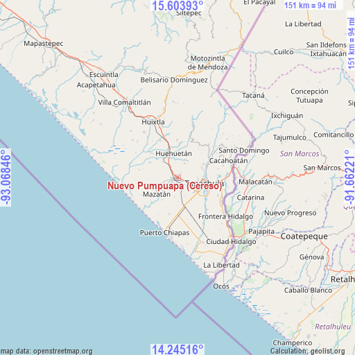
| Upper-left | 15.60393°, | -93.06846° |
| Center: | 14.92562°, | -92.36533° |
| Lower-right: | 14.24516°, | -91.66221° |
| Map W x H: | 151.1×151.1 km | = 93.9×93.9mi |
| max Lat: | 32.7° ⇑99.6% North |
| Nuevo Pumpuapa (Cereso): | 14.92562° |
| min Lat: | ⇓0.4% South 14.53588° |
| min Long | Nuevo Pumpuapa | max Long |
| -117.105° | -92.36533° | -86.73105° |
| W 93%⇐ | ⇒7% E |
Elevation
Elevation of Nuevo Pumpuapa (Cereso) is 45 m = 148 ft, and this is 1208.7 m = 3966 ft below average elevation for this country.
| Max E: |
3497 m = 11473 ft | 84.8% |
| Avg. | 1253.7 m = 4113 ft | |
| Nuevo Pumpuapa (Cereso) | 45 m = 148 ft | |
Min E: |
-1 m = -3 ft | 15.2% |
See also: Mexico elevation on elevation.city.
Geographical zone
Nuevo Pumpuapa (Cereso) is located in North Torrid zone (between Equator and Tropic of Cancer). Distance of this Northern Tropic circle is 946.3 km =588 mi to North.| Distance of | km | miles | from Nuevo Pumpuapa (Cereso) |
|---|---|---|---|
| North Pole | 8347.5 | 5186.9 | to North |
| Arctic Circle | 5741.6 | 3567.7 | to North |
| Tropic Cancer | 946.3 | 588 | to North |
| Equator | 1659.6 | 1031.2 | to South |


Nearby cities:
15 places around Nuevo Pumpuapa (Cereso): (largest is in red/bold)
• Cuatro Caminos
8.4 km =5.2 mi,  215°
215°
• Francisco I. Madero (La Bolsa de la Botella)
8.1 km =5 mi,  190°
190°
• Guachipilín
9.6 km =6 mi,  312°
312°
• Guadalupe
6.7 km =4.2 mi,  24°
24°
• Hidalgo
4.7 km =2.9 mi,  173°
173°
• Juan Sabines Gutiérrez (Poste Rojo)
1.9 km =1.2 mi,  111°
111°
• Los Cafetales
9.4 km =5.8 mi,  133°
133°
• Marte R. Gómez
8.4 km =5.2 mi,  270°
270°
• Pacayalito Dos
4.8 km =3 mi,  116°
116°
• Raymundo Enríquez
8.5 km =5.3 mi,  140°
140°
• Río Florido
8.3 km =5.2 mi,  161°
161°
• Unión Miramar
2.6 km =1.6 mi,  33°
33°
• Vida Mejor I
8.8 km =5.5 mi, 135°
• Viva México
4.6 km =2.9 mi, 112°
• Álvaro Obregón
1.4 km =0.9 mi,  255°
255°
Sources, notices
• [Note1] Compared only with cities in Mexico existing in our database
• [Src1] Map data: © OpenStreetMap contributors (CC-BY-SA)
• [Src2] Other city data from geonames.org with taken over terms of usage.
• [Src3] Geographical zone / Annual Mean Temperature by Robert A. Rohde @ Wikipedia
