Juan Sabines Gutiérrez (Poste Rojo) geodata
Juan Sabines Gutiérrez (Poste Rojo) (Chiapas) is a populated place; located in Mexico in America/Mexico_City (GMT-6) time zone. With population of 883 people, there are 9888 cities with bigger population in this country. Compared to other cities in Mexico, 99.6% of cities are located further ↑North; 93.1% of cities are located further ←West and 82.6% of cities have higher elevation than Juan Sabines Gutiérrez (Poste Rojo). Note1
Current local time in Juan Sabines Gutiérrez (Poste Rojo):
08:42 AM, MondayDifference from your time zone: hours


Juan Sabines Gutiérrez (Poste Rojo) GPS coordinates[2]
14° 55' 9.012" North, 92° 20' 54.996" West
| Map corner | latitude | longitude |
|---|---|---|
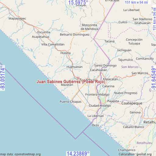
| Upper-left | 15.5975°, | -93.05174° |
| Center: | 14.91917°, | -92.34861° |
| Lower-right: | 14.23869°, | -91.64549° |
| Map W x H: | 151.1×151.1 km | = 93.9×93.9mi |
| max Lat: | 32.7° ⇑99.6% North |
| Juan Sabines Gutiérrez (Poste Rojo): | 14.91917° |
| min Lat: | ⇓0.4% South 14.53588° |
| min Long | Juan Sabines Gu | max Long |
| -117.105° | -92.34861° | -86.73105° |
| W 93.1%⇐ | ⇒6.9% E |
Elevation
Elevation of Juan Sabines Gutiérrez (Poste Rojo) is 64 m = 210 ft, and this is 1189.7 m = 3903 ft below average elevation for this country.
| Max E: |
3497 m = 11473 ft | 82.6% |
| Avg. | 1253.7 m = 4113 ft | |
| Juan Sabines Gutiérrez (Poste Rojo) | 64 m = 210 ft | |
Min E: |
-1 m = -3 ft | 17.4% |
See also: Mexico elevation on elevation.city.
Geographical zone
Juan Sabines Gutiérrez (Poste Rojo) is located in North Torrid zone (between Equator and Tropic of Cancer). Distance of this Northern Tropic circle is 947.1 km =588.5 mi to North.| Distance of | km | miles | from Juan Sabines Gutiérrez (Poste Rojo) |
|---|---|---|---|
| North Pole | 8348.2 | 5187.3 | to North |
| Arctic Circle | 5742.3 | 3568.1 | to North |
| Tropic Cancer | 947.1 | 588.5 | to North |
| Equator | 1658.9 | 1030.8 | to South |


Nearby cities:
15 places around Juan Sabines Gutiérrez (Poste Rojo): (largest is in red/bold)
• Cebadilla 1ra. Sección
9.6 km =6 mi,  129°
129°
• Cuatro Caminos
9 km =5.6 mi,  227°
227°
• Francisco I. Madero (La Bolsa de la Botella)
7.9 km =4.9 mi,  204°
204°
• Guadalupe
6.9 km =4.3 mi,  8°
8°
• Hidalgo
4.1 km =2.5 mi, 198°
• Llano de la Lima
8.1 km =5 mi,  136°
136°
• Los Cafetales
7.6 km =4.7 mi, 138°
• Nuevo Pumpuapa (Cereso)
1.9 km =1.2 mi,  291°
291°
• Pacayalito Dos
2.9 km =1.8 mi,  119°
119°
• Raymundo Enríquez
6.8 km =4.2 mi,  147°
147°
• Río Florido
7.2 km =4.5 mi,  173°
173°
• Unión Miramar
2.9 km =1.8 mi,  352°
352°
• Vida Mejor I
7 km =4.3 mi, 141°
• Viva México
2.6 km =1.6 mi,  112°
112°
• Álvaro Obregón
3.2 km =2 mi,  276°
276°
Sources, notices
• [Note1] Compared only with cities in Mexico existing in our database
• [Src1] Map data: © OpenStreetMap contributors (CC-BY-SA)
• [Src2] Other city data from geonames.org with taken over terms of usage.
• [Src3] Geographical zone / Annual Mean Temperature by Robert A. Rohde @ Wikipedia
