Guadalupe Tlachco geodata
Guadalupe Tlachco (Tlaxcala) is a populated place; located in Mexico in America/Mexico_City (GMT-6) time zone. With population of 3,350 people, there are 2714 cities with bigger population in this country. Compared to other cities in Mexico, 58.1% of cities are located further ↑North; 62.4% of cities are located further ←West and 92.5% of cities have lower elevation than Guadalupe Tlachco. Note1


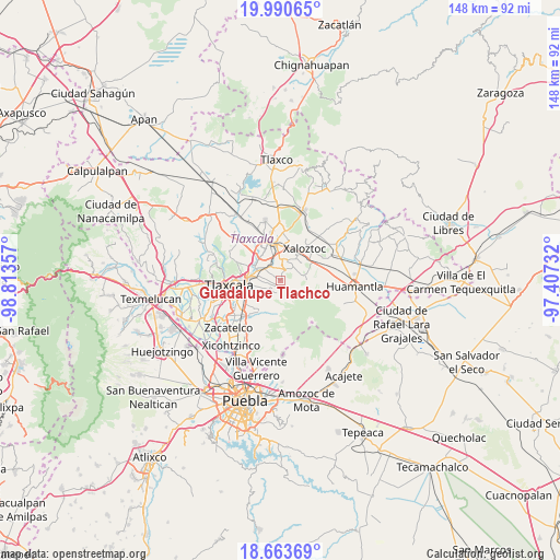
Guadalupe Tlachco GPS coordinates[2]
19° 19' 42.672" North, 98° 6' 37.584" West
| Map corner | latitude | longitude |
|---|---|---|
| Upper-left | 19.99065°, | -98.81357° |
| Center: | 19.32852°, | -98.11044° |
| Lower-right: | 18.66369°, | -97.40732° |
| Map W x H: | 147.5×147.5 km | = 91.7×91.7mi |
| max Lat: | 32.7° ⇑58.1% North |
| Guadalupe Tlachco: | 19.32852° |
| min Lat: | ⇓41.9% South 14.53588° |
| min Long | Guadalupe Tlach | max Long |
| -117.105° | -98.11044° | -86.73105° |
| W 62.4%⇐ | ⇒37.6% E |
Elevation
Elevation of Guadalupe Tlachco is 2509 m = 8232 ft, and this is 1255.3 m = 4118 ft above average elevation for this country.
| Max E: |
3497 m = 11473 ft | 7.5% |
| Guadalupe Tlachco | 2509 m 8232 ft | |
| Avg. | 1253.7 m = 4113 ft | |
Min E: |
-1 m = -3 ft | 92.5% |
See also: Mexico elevation on elevation.city.
Geographical zone
Guadalupe Tlachco is located in North Torrid zone (between Equator and Tropic of Cancer). Distance of this Northern Tropic circle is 456.8 km =283.8 mi to North.| Distance of | km | miles | from Guadalupe Tlachco |
|---|---|---|---|
| North Pole | 7857.9 | 4882.7 | to North |
| Arctic Circle | 5252 | 3263.4 | to North |
| Tropic Cancer | 456.8 | 283.8 | to North |
| Equator | 2149.1 | 1335.4 | to South |


Nearby cities:
15 places around Guadalupe Tlachco: (largest is in red/bold)
• Cuaxomulco
3 km =1.9 mi,  28°
28°
• Ixtlahuaca
3.5 km =2.2 mi,  248°
248°
• Jesús Huitznahuac
2.4 km =1.5 mi,  310°
310°
• La Luz [Barrio]
1.4 km =0.9 mi,  206°
206°
• Ocotlán Tepatlaxco
3.1 km =1.9 mi,  193°
193°
• San José Aztatla
2.7 km =1.7 mi,  219°
219°
• San José Teacalco
4.9 km =3 mi,  80°
80°
• San Lorenzo Xaltelulco
1.4 km =0.9 mi,  19°
19°
• San Lucas Tlacochcalco
4.1 km =2.5 mi,  292°
292°
• San Miguel Buenavista
4.8 km =3 mi,  52°
52°
• San Miguel Contla
4.3 km =2.7 mi,  327°
327°
• San Pedro Xochiteotla
3.7 km =2.3 mi,  232°
232°
• San Rafael Tepatlaxco
3.5 km =2.2 mi,  196°
196°
• Santa Cruz Tlaxcala
5.1 km =3.2 mi,  304°
304°
• Santa María Aquiáhuac
2.1 km =1.3 mi, 249°
Sources, notices
• [Note1] Compared only with cities in Mexico existing in our database
• [Src1] Map data: © OpenStreetMap contributors (CC-BY-SA)
• [Src2] Other city data from geonames.org with taken over terms of usage.
• [Src3] Geographical zone / Annual Mean Temperature by Robert A. Rohde @ Wikipedia
