San José Teacalco geodata
San José Teacalco (Tlaxcala) is a populated place; located in Mexico in America/Mexico_City (GMT-6) time zone. With population of 5,381 people, there are 1726 cities with bigger population in this country. Compared to other cities in Mexico, 58% of cities are located further ↑North; 62.8% of cities are located further ←West and 95.5% of cities have lower elevation than San José Teacalco. Note1


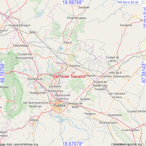
San José Teacalco GPS coordinates[2]
19° 20' 8.088" North, 98° 3' 52.38" West
| Map corner | latitude | longitude |
|---|---|---|
| Upper-left | 19.99768°, | -98.76768° |
| Center: | 19.33558°, | -98.06455° |
| Lower-right: | 18.67078°, | -97.36143° |
| Map W x H: | 147.5×147.5 km | = 91.7×91.7mi |
| max Lat: | 32.7° ⇑58% North |
| San José Teacalco: | 19.33558° |
| min Lat: | ⇓42% South 14.53588° |
| min Long | San José Teaca | max Long |
| -117.105° | -98.06455° | -86.73105° |
| W 62.8%⇐ | ⇒37.2% E |
Elevation
Elevation of San José Teacalco is 2609 m = 8560 ft, and this is 1355.3 m = 4447 ft above average elevation for this country.
| Max E: |
3497 m = 11473 ft | 4.5% |
| San José Teacalco | 2609 m 8560 ft | |
| Avg. | 1253.7 m = 4113 ft | |
Min E: |
-1 m = -3 ft | 95.5% |
See also: Mexico elevation on elevation.city.
Geographical zone
San José Teacalco is located in North Torrid zone (between Equator and Tropic of Cancer). Distance of this Northern Tropic circle is 456 km =283.3 mi to North.| Distance of | km | miles | from San José Teacalco |
|---|---|---|---|
| North Pole | 7857.1 | 4882.2 | to North |
| Arctic Circle | 5251.3 | 3263 | to North |
| Tropic Cancer | 456 | 283.3 | to North |
| Equator | 2149.9 | 1335.9 | to South |


Nearby cities:
15 places around San José Teacalco: (largest is in red/bold)
• Cuaxomulco
3.9 km =2.4 mi,  299°
299°
• Guadalupe Tlachco
4.9 km =3 mi,  260°
260°
• Jesús Huitznahuac
6.7 km =4.2 mi,  276°
276°
• La Luz [Barrio]
5.8 km =3.6 mi,  249°
249°
• Ocotlán Tepatlaxco
6.7 km =4.2 mi,  235°
235°
• San Andrés Ahuashuatepec
6.5 km =4 mi,  317°
317°
• San Juan Quetzalcoapan
4.9 km =3 mi,  351°
351°
• San Lorenzo Xaltelulco
4.4 km =2.7 mi, 277°
• San Miguel Buenavista
2.3 km =1.4 mi,  333°
333°
• San Pedro Tlacotepec
7 km =4.3 mi,  16°
16°
• San Rafael Tepatlaxco
7.1 km =4.4 mi,  234°
234°
• Santa María Aquiáhuac
6.9 km =4.3 mi, 257°
• Tocatlán
7.1 km =4.4 mi,  33°
33°
• Tzompantepec
5.2 km =3.2 mi, 329°
• Xaltianquisco
4.2 km =2.6 mi, 334°
Sources, notices
• [Note1] Compared only with cities in Mexico existing in our database
• [Src1] Map data: © OpenStreetMap contributors (CC-BY-SA)
• [Src2] Other city data from geonames.org with taken over terms of usage.
• [Src3] Geographical zone / Annual Mean Temperature by Robert A. Rohde @ Wikipedia
