San Miguel Contla geodata
San Miguel Contla (Tlaxcala) is a populated place; located in Mexico in America/Mexico_City (GMT-6) time zone. With population of 5,761 people, there are 1614 cities with bigger population in this country. Compared to other cities in Mexico, 57.3% of cities are located further ↑North; 62.1% of cities are located further ←West and 88.6% of cities have lower elevation than San Miguel Contla. Note1


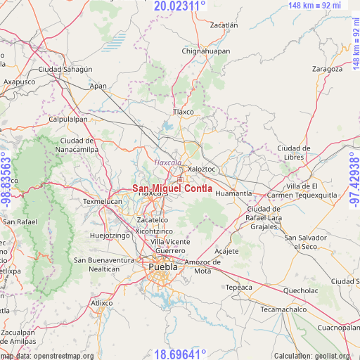
San Miguel Contla GPS coordinates[2]
19° 21' 39.996" North, 98° 7' 57" West
| Map corner | latitude | longitude |
|---|---|---|
| Upper-left | 20.02311°, | -98.83563° |
| Center: | 19.36111°, | -98.1325° |
| Lower-right: | 18.69641°, | -97.42938° |
| Map W x H: | 147.5×147.5 km | = 91.7×91.7mi |
| max Lat: | 32.7° ⇑57.3% North |
| San Miguel Contla: | 19.36111° |
| min Lat: | ⇓42.7% South 14.53588° |
| min Long | San Miguel Cont | max Long |
| -117.105° | -98.1325° | -86.73105° |
| W 62.1%⇐ | ⇒37.9% E |
Elevation
Elevation of San Miguel Contla is 2360 m = 7743 ft, and this is 1106.3 m = 3630 ft above average elevation for this country.
| Max E: |
3497 m = 11473 ft | 11.4% |
| San Miguel Contla | 2360 m 7743 ft | |
| Avg. | 1253.7 m = 4113 ft | |
Min E: |
-1 m = -3 ft | 88.6% |
See also: Mexico elevation on elevation.city.
Geographical zone
San Miguel Contla is located in North Torrid zone (between Equator and Tropic of Cancer). Distance of this Northern Tropic circle is 453.2 km =281.6 mi to North.| Distance of | km | miles | from San Miguel Contla |
|---|---|---|---|
| North Pole | 7854.3 | 4880.4 | to North |
| Arctic Circle | 5248.4 | 3261.2 | to North |
| Tropic Cancer | 453.2 | 281.6 | to North |
| Equator | 2152.8 | 1337.7 | to South |


Nearby cities:
15 places around San Miguel Contla: (largest is in red/bold)
• Amaxac de Guerrero
4.3 km =2.7 mi,  248°
248°
• Contla
5 km =3.1 mi,  225°
225°
• Cuaxomulco
3.9 km =2.4 mi,  104°
104°
• Guadalupe Tlachco
4.3 km =2.7 mi,  147°
147°
• Ixtlahuaca
5 km =3.1 mi,  191°
191°
• Jesús Huitznahuac
2.1 km =1.3 mi,  167°
167°
• La Luz [Barrio]
5.1 km =3.2 mi,  160°
160°
• San Andrés Ahuashuatepec
3.3 km =2.1 mi,  54°
54°
• San José Tepoxtla
3.4 km =2.1 mi,  311°
311°
• San Lorenzo Xaltelulco
3.6 km =2.2 mi,  128°
128°
• San Lucas Tlacochcalco
2.5 km =1.6 mi,  215°
215°
• Santa Anita Huiloac
3.3 km =2.1 mi,  338°
338°
• Santa Cruz Tlaxcala
2 km =1.2 mi, 249°
• Santa María Aquiáhuac
4.4 km =2.7 mi,  175°
175°
• Tzompantepec
4.7 km =2.9 mi,  69°
69°
Sources, notices
• [Note1] Compared only with cities in Mexico existing in our database
• [Src1] Map data: © OpenStreetMap contributors (CC-BY-SA)
• [Src2] Other city data from geonames.org with taken over terms of usage.
• [Src3] Geographical zone / Annual Mean Temperature by Robert A. Rohde @ Wikipedia
