Cerritos geodata
Cerritos (Veracruz) is a populated place; located in Mexico in America/Mexico_City (GMT-6) time zone. With population of 1,397 people, there are 6196 cities with bigger population in this country. Compared to other cities in Mexico, 62.5% of cities are located further ↑North; 79.1% of cities are located further ←West and 71.2% of cities have higher elevation than Cerritos. Note1


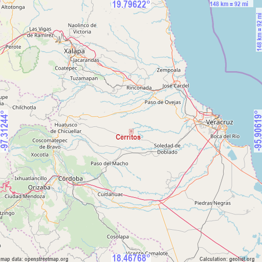
Cerritos GPS coordinates[2]
19° 7' 59.844" North, 96° 36' 33.516" West
| Map corner | latitude | longitude |
|---|---|---|
| Upper-left | 19.79622°, | -97.31244° |
| Center: | 19.13329°, | -96.60931° |
| Lower-right: | 18.46768°, | -95.90619° |
| Map W x H: | 147.7×147.7 km | = 91.8×91.8mi |
| max Lat: | 32.7° ⇑62.5% North |
| Cerritos: | 19.13329° |
| min Lat: | ⇓37.5% South 14.53588° |
| min Long | Cerritos | max Long |
| -117.105° | -96.60931° | -86.73105° |
| W 79.1%⇐ | ⇒20.9% E |
Elevation
Elevation of Cerritos is 360 m = 1181 ft, and this is 893.7 m = 2932 ft below average elevation for this country.
| Max E: |
3497 m = 11473 ft | 71.2% |
| Avg. | 1253.7 m = 4113 ft | |
| Cerritos | 360 m = 1181 ft | |
Min E: |
-1 m = -3 ft | 28.8% |
See also: Mexico elevation on elevation.city.
Geographical zone
Cerritos is located in North Torrid zone (between Equator and Tropic of Cancer). Distance of this Northern Tropic circle is 478.5 km =297.3 mi to North.| Distance of | km | miles | from Cerritos |
|---|---|---|---|
| North Pole | 7879.6 | 4896.2 | to North |
| Arctic Circle | 5273.8 | 3277 | to North |
| Tropic Cancer | 478.5 | 297.3 | to North |
| Equator | 2127.4 | 1321.9 | to South |


Nearby cities:
15 places around Cerritos: (largest is in red/bold)
• Acazónica
9.1 km =5.7 mi,  13°
13°
• Angostillo
11.8 km =7.3 mi,  37°
37°
• Camarón de Tejeda
12.4 km =7.7 mi,  182°
182°
• Cantarranas
15 km =9.3 mi,  29°
29°
• El Jobo
12 km =7.5 mi,  269°
269°
• Hato de la Higuera
13.7 km =8.5 mi,  332°
332°
• La Mestiza
16.3 km =10.1 mi,  166°
166°
• Mata Cazuela
16.8 km =10.4 mi,  84°
84°
• Mata de Varas
14.2 km =8.8 mi,  207°
207°
• Pachuquilla
11.6 km =7.2 mi,  358°
358°
• Paso Lagarto
11.5 km =7.1 mi,  108°
108°
• Paso Pimienta
9.5 km =5.9 mi,  263°
263°
• Rincón de Barrabás
16.1 km =10 mi,  151°
151°
• San Francisco Nacaxtle
2.9 km =1.8 mi, 150°
• Sonora
3.6 km =2.2 mi,  229°
229°
Sources, notices
• [Note1] Compared only with cities in Mexico existing in our database
• [Src1] Map data: © OpenStreetMap contributors (CC-BY-SA)
• [Src2] Other city data from geonames.org with taken over terms of usage.
• [Src3] Geographical zone / Annual Mean Temperature by Robert A. Rohde @ Wikipedia
