Camarón de Tejeda geodata
Camarón de Tejeda (Veracruz) is a seat of a second-order administrative division; located in Mexico in America/Mexico_City (GMT-6) time zone. With population of 2,106 people, there are 4147 cities with bigger population in this country. Compared to other cities in Mexico, 64.3% of cities are located further ↑North; 79.1% of cities are located further ←West and 71.4% of cities have higher elevation than Camarón de Tejeda. Note1


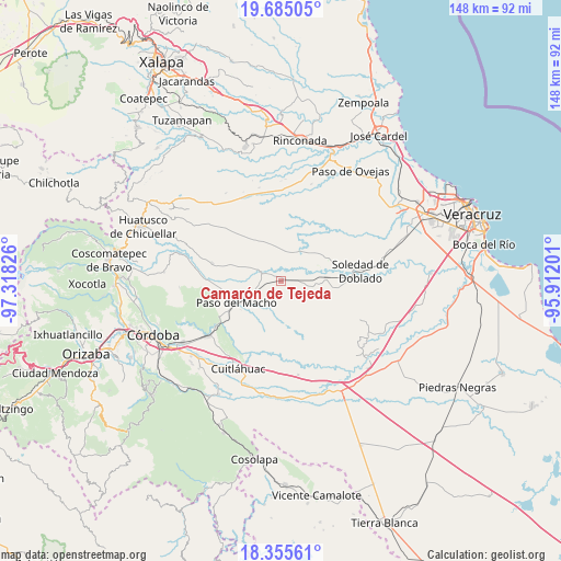
Camarón de Tejeda GPS coordinates[2]
19° 1' 17.976" North, 96° 36' 54.468" West
| Map corner | latitude | longitude |
|---|---|---|
| Upper-left | 19.68505°, | -97.31826° |
| Center: | 19.02166°, | -96.61513° |
| Lower-right: | 18.35561°, | -95.91201° |
| Map W x H: | 147.8×147.8 km | = 91.8×91.8mi |
| max Lat: | 32.7° ⇑64.3% North |
| Camarón de Tejeda: | 19.02166° |
| min Lat: | ⇓35.7% South 14.53588° |
| min Long | Camarón de Tej | max Long |
| -117.105° | -96.61513° | -86.73105° |
| W 79.1%⇐ | ⇒20.9% E |
Elevation
Elevation of Camarón de Tejeda is 352 m = 1155 ft, and this is 901.7 m = 2958 ft below average elevation for this country.
| Max E: |
3497 m = 11473 ft | 71.4% |
| Avg. | 1253.7 m = 4113 ft | |
| Camarón de Tejeda | 352 m = 1155 ft | |
Min E: |
-1 m = -3 ft | 28.6% |
See also: Mexico elevation on elevation.city.
Geographical zone
Camarón de Tejeda is located in North Torrid zone (between Equator and Tropic of Cancer). Distance of this Northern Tropic circle is 490.9 km =305 mi to North.| Distance of | km | miles | from Camarón de Tejeda |
|---|---|---|---|
| North Pole | 7892.1 | 4903.9 | to North |
| Arctic Circle | 5286.2 | 3284.7 | to North |
| Tropic Cancer | 490.9 | 305 | to North |
| Equator | 2115 | 1314.2 | to South |


Nearby cities:
15 places around Camarón de Tejeda: (largest is in red/bold)
• Buenos Aires
18.3 km =11.4 mi,  240°
240°
• Cerritos
12.4 km =7.7 mi,  2°
2°
• Ejido la Piña (Maromilla)
17.7 km =11 mi,  272°
272°
• El Jobo
16.8 km =10.4 mi,  317°
317°
• La Mestiza
5.7 km =3.5 mi,  126°
126°
• Mata Naranjo
15.8 km =9.8 mi,  263°
263°
• Mata de Varas
5.9 km =3.7 mi, 267°
• Paso Lagarto
14.5 km =9 mi,  52°
52°
• Paso Pimienta
14.4 km =8.9 mi, 322°
• Paso del Macho
12.8 km =8 mi, 243°
• Rincón de Barrabás
8.5 km =5.3 mi,  101°
101°
• Salvador Esquer Apodaca [Unidad Habitacional]
13.2 km =8.2 mi, 237°
• San Francisco Nacaxtle
10.1 km =6.3 mi,  11°
11°
• San José Balsa Camarón
13.4 km =8.3 mi,  224°
224°
• Sonora
10.3 km =6.4 mi,  348°
348°
Sources, notices
• [Note1] Compared only with cities in Mexico existing in our database
• [Src1] Map data: © OpenStreetMap contributors (CC-BY-SA)
• [Src2] Other city data from geonames.org with taken over terms of usage.
• [Src3] Geographical zone / Annual Mean Temperature by Robert A. Rohde @ Wikipedia
