Cacahoatán geodata
Cacahoatán (Chiapas) is a seat of a second-order administrative division; located in Mexico in America/Mexico_City (GMT-6) time zone. With population of 16,572 people, there are 579 cities with bigger population in this country. Compared to other cities in Mexico, 99.5% of cities are located further ↑North; 94.4% of cities are located further ←West and 68.5% of cities have higher elevation than Cacahoatán. Note1


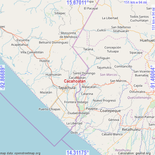
Cacahoatán GPS coordinates[2]
14° 59' 31.236" North, 92° 9' 49.536" West
| Map corner | latitude | longitude |
|---|---|---|
| Upper-left | 15.67011°, | -92.86689° |
| Center: | 14.99201°, | -92.16376° |
| Lower-right: | 14.31175°, | -91.46064° |
| Map W x H: | 151×151 km | = 93.8×93.8mi |
| max Lat: | 32.7° ⇑99.5% North |
| Cacahoatán: | 14.99201° |
| min Lat: | ⇓0.5% South 14.53588° |
| min Long | Cacahoatán | max Long |
| -117.105° | -92.16376° | -86.73105° |
| W 94.4%⇐ | ⇒5.6% E |
Elevation
Elevation of Cacahoatán is 498 m = 1634 ft, and this is 755.7 m = 2479 ft below average elevation for this country.
| Max E: |
3497 m = 11473 ft | 68.5% |
| Avg. | 1253.7 m = 4113 ft | |
| Cacahoatán | 498 m = 1634 ft | |
Min E: |
-1 m = -3 ft | 31.5% |
See also: Mexico elevation on elevation.city.
Geographical zone
Cacahoatán is located in North Torrid zone (between Equator and Tropic of Cancer). Distance of this Northern Tropic circle is 939 km =583.5 mi to North.| Distance of | km | miles | from Cacahoatán |
|---|---|---|---|
| North Pole | 8340.1 | 5182.3 | to North |
| Arctic Circle | 5734.2 | 3563.1 | to North |
| Tropic Cancer | 939 | 583.5 | to North |
| Equator | 1667 | 1035.8 | to South |


Nearby cities:
15 places around Cacahoatán: (largest is in red/bold)
• Ahuacatlán
5.7 km =3.5 mi,  341°
341°
• Carrillo Puerto
4 km =2.5 mi,  302°
302°
• Dos de Mayo
3.7 km =2.3 mi,  24°
24°
• El Carmen
4.3 km =2.7 mi,  0°
0°
• Faja de Oro
4.6 km =2.9 mi,  10°
10°
• Hermosillo
3.6 km =2.2 mi,  273°
273°
• Los Ángeles
6 km =3.7 mi, 302°
• Manuel Lazos
3.4 km =2.1 mi,  228°
228°
• Mixcum
4.5 km =2.8 mi,  33°
33°
• Rosario Ixtal
1.9 km =1.2 mi, 30°
• San Agustín Jitotol
5.6 km =3.5 mi,  275°
275°
• Sección la Toma
3.3 km =2.1 mi,  179°
179°
• Silvano Gatica
5.8 km =3.6 mi, 231°
• Talismán
3.7 km =2.3 mi,  150°
150°
• Tuxtla Chico
5.9 km =3.7 mi, 183°
Sources, notices
• [Note1] Compared only with cities in Mexico existing in our database
• [Src1] Map data: © OpenStreetMap contributors (CC-BY-SA)
• [Src2] Other city data from geonames.org with taken over terms of usage.
• [Src3] Geographical zone / Annual Mean Temperature by Robert A. Rohde @ Wikipedia
