San Agustín Jitotol geodata
San Agustín Jitotol (Chiapas) is a populated place; located in Mexico in America/Mexico_City (GMT-6) time zone. With population of 579 people, there are 14804 cities with bigger population in this country. Compared to other cities in Mexico, 99.5% of cities are located further ↑North; 94% of cities are located further ←West and 69.5% of cities have higher elevation than San Agustín Jitotol. Note1


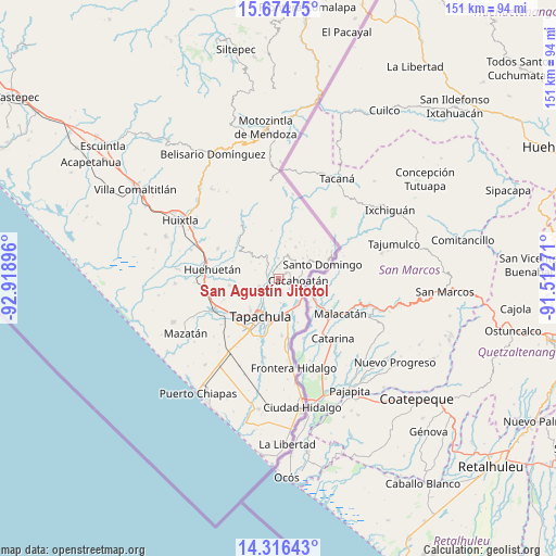
San Agustín Jitotol GPS coordinates[2]
14° 59' 48.012" North, 92° 12' 56.988" West
| Map corner | latitude | longitude |
|---|---|---|
| Upper-left | 15.67475°, | -92.91896° |
| Center: | 14.99667°, | -92.21583° |
| Lower-right: | 14.31643°, | -91.51271° |
| Map W x H: | 151×151 km | = 93.8×93.8mi |
| max Lat: | 32.7° ⇑99.5% North |
| San Agustín Jitotol: | 14.99667° |
| min Lat: | ⇓0.5% South 14.53588° |
| min Long | San Agustín Ji | max Long |
| -117.105° | -92.21583° | -86.73105° |
| W 94%⇐ | ⇒6% E |
Elevation
Elevation of San Agustín Jitotol is 442 m = 1450 ft, and this is 811.7 m = 2663 ft below average elevation for this country.
| Max E: |
3497 m = 11473 ft | 69.5% |
| Avg. | 1253.7 m = 4113 ft | |
| San Agustín Jitotol | 442 m = 1450 ft | |
Min E: |
-1 m = -3 ft | 30.5% |
See also: Mexico elevation on elevation.city.
Geographical zone
San Agustín Jitotol is located in North Torrid zone (between Equator and Tropic of Cancer). Distance of this Northern Tropic circle is 938.4 km =583.1 mi to North.| Distance of | km | miles | from San Agustín Jitotol |
|---|---|---|---|
| North Pole | 8339.6 | 5182 | to North |
| Arctic Circle | 5733.7 | 3562.8 | to North |
| Tropic Cancer | 938.4 | 583.1 | to North |
| Equator | 1667.5 | 1036.1 | to South |


Nearby cities:
15 places around San Agustín Jitotol: (largest is in red/bold)
• Ahuacatlán
6.2 km =3.9 mi,  38°
38°
• Cacahoatán
5.6 km =3.5 mi,  95°
95°
• Carrillo Puerto
2.7 km =1.7 mi,  53°
53°
• El Chaparrón
3.8 km =2.4 mi,  236°
236°
• El Triunfo
0.9 km =0.6 mi,  225°
225°
• Fracción Galeras
6.5 km =4 mi,  346°
346°
• Fracción las Palmas
5.7 km =3.5 mi,  339°
339°
• Hermosillo
2 km =1.2 mi, 98°
• Los Ángeles
2.7 km =1.7 mi,  10°
10°
• Manuel Lazos
4.1 km =2.5 mi,  132°
132°
• Salvador Urbina
4.4 km =2.7 mi, 10°
• Silvano Gatica
4.3 km =2.7 mi,  165°
165°
• Toluca
4.6 km =2.9 mi,  319°
319°
• Unión Roja
5.5 km =3.4 mi,  359°
359°
• Veinte de Noviembre
5.7 km =3.5 mi,  247°
247°
Sources, notices
• [Note1] Compared only with cities in Mexico existing in our database
• [Src1] Map data: © OpenStreetMap contributors (CC-BY-SA)
• [Src2] Other city data from geonames.org with taken over terms of usage.
• [Src3] Geographical zone / Annual Mean Temperature by Robert A. Rohde @ Wikipedia
