Atlixco geodata
Atlixco (Puebla) is a populated place; located in Mexico in America/Mexico_City (GMT-6) time zone. With population of 86,690 people, there are 146 cities with bigger population in this country. Compared to other cities in Mexico, 66.8% of cities are located further ↑North; 58.1% of cities are located further ←West and 65.8% of cities have lower elevation than Atlixco. Note1


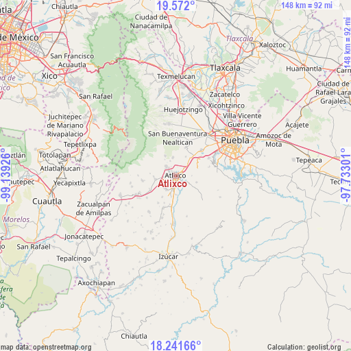
Atlixco GPS coordinates[2]
18° 54' 29.34" North, 98° 26' 10.068" West
| Map corner | latitude | longitude |
|---|---|---|
| Upper-left | 19.572°, | -99.13926° |
| Center: | 18.90815°, | -98.43613° |
| Lower-right: | 18.24166°, | -97.73301° |
| Map W x H: | 147.9×147.9 km | = 91.9×91.9mi |
| max Lat: | 32.7° ⇑66.8% North |
| Atlixco: | 18.90815° |
| min Lat: | ⇓33.2% South 14.53588° |
| min Long | Atlixco | max Long |
| -117.105° | -98.43613° | -86.73105° |
| W 58.1%⇐ | ⇒41.9% E |
Elevation
Elevation of Atlixco is 1846 m = 6056 ft, and this is 592.3 m = 1943 ft above average elevation for this country.
| Max E: |
3497 m = 11473 ft | 34.2% |
| Atlixco | 1846 m 6056 ft | |
| Avg. | 1253.7 m = 4113 ft | |
Min E: |
-1 m = -3 ft | 65.8% |
See also: Atlixco elevation on elevation.city.
Geographical zone
Atlixco is located in North Torrid zone (between Equator and Tropic of Cancer). Distance of this Northern Tropic circle is 503.5 km =312.9 mi to North.| Distance of | km | miles | from Atlixco |
|---|---|---|---|
| North Pole | 7904.7 | 4911.8 | to North |
| Arctic Circle | 5298.8 | 3292.5 | to North |
| Tropic Cancer | 503.5 | 312.9 | to North |
| Equator | 2102.4 | 1306.4 | to South |


Nearby cities:
15 places around Atlixco: (largest is in red/bold)
• Ciudad de Atlixco
0.6 km =0.4 mi,  213°
213°
• El Encanto del Cerril
2.9 km =1.8 mi,  22°
22°
• Emiliano Zapata Nexatengo
4 km =2.5 mi,  136°
136°
• Emiliano Zapata los Molinos
6.3 km =3.9 mi,  45°
45°
• Juan Uvera
5.1 km =3.2 mi,  163°
163°
• San Agustín Huixaxtla
4.3 km =2.7 mi,  75°
75°
• San Félix Almazán
5.8 km =3.6 mi,  117°
117°
• San Félix Hidalgo
4 km =2.5 mi,  104°
104°
• San Isidro Huilotepec
6.4 km =4 mi, 118°
• San Juan Tejaluca
3.5 km =2.2 mi,  106°
106°
• San Martín Tlapala
6.9 km =4.3 mi,  339°
339°
• Santa Ana Acozautla
7.7 km =4.8 mi, 46°
• Santa Ana Yancuitlalpan (Chilhuacán)
4.6 km =2.9 mi, 124°
• Santo Domingo Atoyatempan
6.6 km =4.1 mi,  93°
93°
• Tianguismanalco
7.7 km =4.8 mi,  350°
350°
Sources, notices
• [Note1] Compared only with cities in Mexico existing in our database
• [Src1] Map data: © OpenStreetMap contributors (CC-BY-SA)
• [Src2] Other city data from geonames.org with taken over terms of usage.
• [Src3] Geographical zone / Annual Mean Temperature by Robert A. Rohde @ Wikipedia
