Astapa geodata
Astapa (Tabasco) is a populated place; located in Mexico in America/Mexico_City (GMT-6) time zone. With population of 1,215 people, there are 7154 cities with bigger population in this country. Compared to other cities in Mexico, 80.7% of cities are located further ↑North; 89.5% of cities are located further ←West and 94% of cities have higher elevation than Astapa. Note1


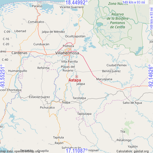
Astapa GPS coordinates[2]
17° 46' 53.94" North, 92° 50' 57.768" West
| Map corner | latitude | longitude |
|---|---|---|
| Upper-left | 18.44992°, | -93.55251° |
| Center: | 17.78165°, | -92.84938° |
| Lower-right: | 17.11087°, | -92.14626° |
| Map W x H: | 148.9×148.9 km | = 92.5×92.5mi |
| max Lat: | 32.7° ⇑80.7% North |
| Astapa: | 17.78165° |
| min Lat: | ⇓19.3% South 14.53588° |
| min Long | Astapa | max Long |
| -117.105° | -92.84938° | -86.73105° |
| W 89.5%⇐ | ⇒10.5% E |
Elevation
Elevation of Astapa is 15 m = 49 ft, and this is 1238.7 m = 4064 ft below average elevation for this country.
| Max E: |
3497 m = 11473 ft | 94% |
| Avg. | 1253.7 m = 4113 ft | |
| Astapa | 15 m = 49 ft | |
Min E: |
-1 m = -3 ft | 6% |
See also: Mexico elevation on elevation.city.
Geographical zone
Astapa is located in North Torrid zone (between Equator and Tropic of Cancer). Distance of this Northern Tropic circle is 628.8 km =390.7 mi to North.| Distance of | km | miles | from Astapa |
|---|---|---|---|
| North Pole | 8029.9 | 4989.5 | to North |
| Arctic Circle | 5424 | 3370.3 | to North |
| Tropic Cancer | 628.8 | 390.7 | to North |
| Equator | 1977.1 | 1228.5 | to South |


Nearby cities:
15 places around Astapa: (largest is in red/bold)
• Aquiles Serdán 1ra. Sección
12.6 km =7.8 mi,  67°
67°
• Aquiles Serdán 2da. Sección
13.8 km =8.6 mi,  58°
58°
• El Rosario y el Quemado
14.5 km =9 mi,  328°
328°
• Emiliano Zapata
0.9 km =0.6 mi,  182°
182°
• Francisco J. Santamaría (Cacao)
5.1 km =3.2 mi,  350°
350°
• Hueso de Puerco
5.1 km =3.2 mi,  279°
279°
• Jahuacapa
5.2 km =3.2 mi,  159°
159°
• Jalapa
7.7 km =4.8 mi,  149°
149°
• Manuel Buelta y Rayón
14 km =8.7 mi,  232°
232°
• Parrilla II
13.3 km =8.3 mi,  324°
324°
• Playas del Rosario
11.8 km =7.3 mi,  312°
312°
• Pueblo Nuevo de las Raíces
7.8 km =4.8 mi,  336°
336°
• Río de Teapa
5.4 km =3.4 mi,  272°
272°
• San Miguel Adentro 1ra. Sección
15.8 km =9.8 mi,  114°
114°
• Santa Fé
15.7 km =9.8 mi, 337°
Sources, notices
• [Note1] Compared only with cities in Mexico existing in our database
• [Src1] Map data: © OpenStreetMap contributors (CC-BY-SA)
• [Src2] Other city data from geonames.org with taken over terms of usage.
• [Src3] Geographical zone / Annual Mean Temperature by Robert A. Rohde @ Wikipedia
