Astacinga geodata
Astacinga (Veracruz) is a seat of a second-order administrative division; located in Mexico in America/Mexico_City (GMT-6) time zone. With population of 723 people, there are 12083 cities with bigger population in this country. Compared to other cities in Mexico, 71.8% of cities are located further ↑North; 73.5% of cities are located further ←West and 87.2% of cities have lower elevation than Astacinga. Note1


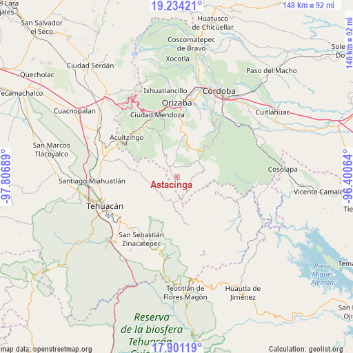
Astacinga GPS coordinates[2]
18° 34' 8.4" North, 97° 6' 13.536" West
| Map corner | latitude | longitude |
|---|---|---|
| Upper-left | 19.23421°, | -97.80689° |
| Center: | 18.569°, | -97.10376° |
| Lower-right: | 17.90119°, | -96.40064° |
| Map W x H: | 148.2×148.2 km | = 92.1×92.1mi |
| max Lat: | 32.7° ⇑71.8% North |
| Astacinga: | 18.569° |
| min Lat: | ⇓28.2% South 14.53588° |
| min Long | Astacinga | max Long |
| -117.105° | -97.10376° | -86.73105° |
| W 73.5%⇐ | ⇒26.5% E |
Elevation
Elevation of Astacinga is 2317 m = 7602 ft, and this is 1063.3 m = 3489 ft above average elevation for this country.
| Max E: |
3497 m = 11473 ft | 12.8% |
| Astacinga | 2317 m 7602 ft | |
| Avg. | 1253.7 m = 4113 ft | |
Min E: |
-1 m = -3 ft | 87.2% |
See also: Mexico elevation on elevation.city.
Geographical zone
Astacinga is located in North Torrid zone (between Equator and Tropic of Cancer). Distance of this Northern Tropic circle is 541.2 km =336.3 mi to North.| Distance of | km | miles | from Astacinga |
|---|---|---|---|
| North Pole | 7942.4 | 4935.2 | to North |
| Arctic Circle | 5336.5 | 3315.9 | to North |
| Tropic Cancer | 541.2 | 336.3 | to North |
| Equator | 2064.7 | 1282.9 | to South |


Nearby cities:
15 places around Astacinga: (largest is in red/bold)
• Acatitla
2.6 km =1.6 mi,  229°
229°
• Acuayucan
2.4 km =1.5 mi,  200°
200°
• Alhuaca
6.6 km =4.1 mi,  268°
268°
• Antiguo Caporalco
7 km =4.3 mi,  242°
242°
• Caporalco Buenos Aires
7.6 km =4.7 mi,  222°
222°
• Cuauyolotitla
6.9 km =4.3 mi,  141°
141°
• Ojo de Agua
7.2 km =4.5 mi,  131°
131°
• Tehuipango
7.6 km =4.7 mi, 136°
• Tepeica
4.8 km =3 mi,  164°
164°
• Tlalixtlahuac
3.5 km =2.2 mi,  146°
146°
• Tlaquilpa
4.8 km =3 mi,  341°
341°
• Xaltepec
7.8 km =4.8 mi, 132°
• Xiujtempa
6.8 km =4.2 mi, 135°
• Xonacayojca
6.3 km =3.9 mi,  170°
170°
• Xopilapa
7.6 km =4.7 mi, 160°
Sources, notices
• [Note1] Compared only with cities in Mexico existing in our database
• [Src1] Map data: © OpenStreetMap contributors (CC-BY-SA)
• [Src2] Other city data from geonames.org with taken over terms of usage.
• [Src3] Geographical zone / Annual Mean Temperature by Robert A. Rohde @ Wikipedia
