Almoloya del Río geodata
Almoloya del Río (State of Mexico) is a seat of a second-order administrative division; located in Mexico in America/Mexico_City (GMT-6) time zone. With population of 9,507 people, there are 1012 cities with bigger population in this country. Compared to other cities in Mexico, 62% of cities are located further ↑North; 56.8% of cities are located further →East and 95.4% of cities have lower elevation than Almoloya del Río. Note1


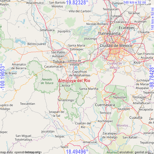
Almoloya del Río GPS coordinates[2]
19° 9' 37.656" North, 99° 29' 14.64" West
| Map corner | latitude | longitude |
|---|---|---|
| Upper-left | 19.82328°, | -100.19053° |
| Center: | 19.16046°, | -99.4874° |
| Lower-right: | 18.49496°, | -98.78428° |
| Map W x H: | 147.7×147.7 km | = 91.8×91.8mi |
| max Lat: | 32.7° ⇑62% North |
| Almoloya del Río: | 19.16046° |
| min Lat: | ⇓38% South 14.53588° |
| min Long | Almoloya del R� | max Long |
| -117.105° | -99.4874° | -86.73105° |
| W 43.2%⇐ | ⇒56.8% E |
Elevation
Elevation of Almoloya del Río is 2604 m = 8543 ft, and this is 1350.3 m = 4430 ft above average elevation for this country.
| Max E: |
3497 m = 11473 ft | 4.6% |
| Almoloya del Río | 2604 m 8543 ft | |
| Avg. | 1253.7 m = 4113 ft | |
Min E: |
-1 m = -3 ft | 95.4% |
See also: Mexico elevation on elevation.city.
Geographical zone
Almoloya del Río is located in North Torrid zone (between Equator and Tropic of Cancer). Distance of this Northern Tropic circle is 475.5 km =295.5 mi to North.| Distance of | km | miles | from Almoloya del Río |
|---|---|---|---|
| North Pole | 7876.6 | 4894.3 | to North |
| Arctic Circle | 5270.7 | 3275.1 | to North |
| Tropic Cancer | 475.5 | 295.5 | to North |
| Equator | 2130.4 | 1323.8 | to South |


Nearby cities:
15 places around Almoloya del Río: (largest is in red/bold)
• Ahuatenco
4.2 km =2.6 mi,  131°
131°
• Capulhuac de Mirafuentes
4.3 km =2.7 mi,  31°
31°
• Colonia Loma Linda
1 km =0.6 mi,  174°
174°
• Colonia la Libertad
3.2 km =2 mi,  329°
329°
• Colonia la Poza
4.4 km =2.7 mi,  11°
11°
• Colonia las Granjas
4.4 km =2.7 mi,  60°
60°
• Mezapa la Fábrica
4.7 km =2.9 mi,  69°
69°
• San José Mezapa Sección I
3.4 km =2.1 mi,  85°
85°
• San Lorenzo Huehuetitlán
3 km =1.9 mi, 169°
• San Mateo Texcalyacac
2.3 km =1.4 mi, 72°
• San Pedro Tlaltizapan
4.5 km =2.8 mi,  343°
343°
• Santa Cruz Atizapán
1.8 km =1.1 mi,  356°
356°
• Santa Fe Mezapa
3.8 km =2.4 mi, 89°
• Santiago Tianguistenco de Galeana
3.1 km =1.9 mi,  45°
45°
• Texcalyacac
3.4 km =2.1 mi,  205°
205°
Sources, notices
• [Note1] Compared only with cities in Mexico existing in our database
• [Src1] Map data: © OpenStreetMap contributors (CC-BY-SA)
• [Src2] Other city data from geonames.org with taken over terms of usage.
• [Src3] Geographical zone / Annual Mean Temperature by Robert A. Rohde @ Wikipedia
