Actopan geodata
Actopan (Hidalgo) is a populated place; located in Mexico in America/Mexico_City (GMT-6) time zone. With population of 29,223 people, there are 341 cities with bigger population in this country. Compared to other cities in Mexico, 62.9% of cities are located further ↓South; 51.2% of cities are located further ←West and 73.9% of cities have lower elevation than Actopan. Note1


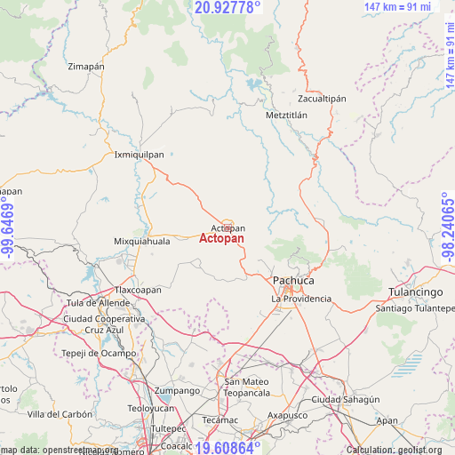
Actopan GPS coordinates[2]
20° 16' 10.596" North, 98° 56' 37.572" West
| Map corner | latitude | longitude |
|---|---|---|
| Upper-left | 20.92778°, | -99.6469° |
| Center: | 20.26961°, | -98.94377° |
| Lower-right: | 19.60864°, | -98.24065° |
| Map W x H: | 146.7×146.7 km | = 91.2×91.2mi |
| max Lat: | 32.7° ⇑37.1% North |
| Actopan: | 20.26961° |
| min Lat: | ⇓62.9% South 14.53588° |
| min Long | Actopan | max Long |
| -117.105° | -98.94377° | -86.73105° |
| W 51.2%⇐ | ⇒48.8% E |
Elevation
Elevation of Actopan is 2008 m = 6588 ft, and this is 754.3 m = 2475 ft above average elevation for this country.
| Max E: |
3497 m = 11473 ft | 26.1% |
| Actopan | 2008 m 6588 ft | |
| Avg. | 1253.7 m = 4113 ft | |
Min E: |
-1 m = -3 ft | 73.9% |
See also: Mexico elevation on elevation.city.
Geographical zone
Actopan is located in North Torrid zone (between Equator and Tropic of Cancer). Distance of this Northern Tropic circle is 352.1 km =218.8 mi to North.| Distance of | km | miles | from Actopan |
|---|---|---|---|
| North Pole | 7753.3 | 4817.7 | to North |
| Arctic Circle | 5147.4 | 3198.4 | to North |
| Tropic Cancer | 352.1 | 218.8 | to North |
| Equator | 2253.8 | 1400.4 | to South |


Nearby cities:
15 places around Actopan: (largest is in red/bold)
• Bothi Bají
3 km =1.9 mi,  183°
183°
• Casa Blanca
5.6 km =3.5 mi,  238°
238°
• Cañada Chica Antigua
4.1 km =2.5 mi,  350°
350°
• Colonia Veinte de Noviembre
3.7 km =2.3 mi,  155°
155°
• Dajiedi
4.6 km =2.9 mi,  4°
4°
• Daxtha
3.9 km =2.4 mi,  287°
287°
• El Boxtha
3.4 km =2.1 mi,  250°
250°
• El Huaxtho
4.4 km =2.7 mi,  206°
206°
• El Jiadi
2.9 km =1.8 mi,  145°
145°
• El Meje
3.1 km =1.9 mi,  112°
112°
• El Rincón
4.1 km =2.5 mi,  84°
84°
• La Loma
1.8 km =1.1 mi,  140°
140°
• La Peña
2.6 km =1.6 mi,  90°
90°
• Poxindeje de Morelos
5.5 km =3.4 mi,  269°
269°
• San Antonio Zaragoza
5.9 km =3.7 mi, 254°
Sources, notices
• [Note1] Compared only with cities in Mexico existing in our database
• [Src1] Map data: © OpenStreetMap contributors (CC-BY-SA)
• [Src2] Other city data from geonames.org with taken over terms of usage.
• [Src3] Geographical zone / Annual Mean Temperature by Robert A. Rohde @ Wikipedia
