Bothi Bají geodata
Bothi Bají (Hidalgo) is a populated place; located in Mexico in America/Mexico_City (GMT-6) time zone. With population of 725 people, there are 12042 cities with bigger population in this country. Compared to other cities in Mexico, 62.3% of cities are located further ↓South; 51.2% of cities are located further ←West and 73.3% of cities have lower elevation than Bothi Bají. Note1


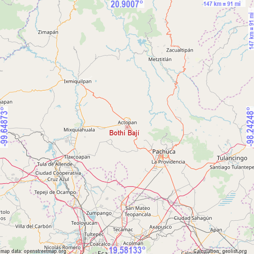
Bothi Bají GPS coordinates[2]
20° 14' 32.712" North, 98° 56' 44.16" West
| Map corner | latitude | longitude |
|---|---|---|
| Upper-left | 20.9007°, | -99.64873° |
| Center: | 20.24242°, | -98.9456° |
| Lower-right: | 19.58133°, | -98.24248° |
| Map W x H: | 146.7×146.7 km | = 91.2×91.2mi |
| max Lat: | 32.7° ⇑37.7% North |
| Bothi Bají: | 20.24242° |
| min Lat: | ⇓62.3% South 14.53588° |
| min Long | Bothi Bají | max Long |
| -117.105° | -98.9456° | -86.73105° |
| W 51.2%⇐ | ⇒48.8% E |
Elevation
Elevation of Bothi Bají is 1998 m = 6555 ft, and this is 744.3 m = 2442 ft above average elevation for this country.
| Max E: |
3497 m = 11473 ft | 26.7% |
| Bothi Bají | 1998 m 6555 ft | |
| Avg. | 1253.7 m = 4113 ft | |
Min E: |
-1 m = -3 ft | 73.3% |
See also: Mexico elevation on elevation.city.
Geographical zone
Bothi Bají is located in North Torrid zone (between Equator and Tropic of Cancer). Distance of this Northern Tropic circle is 355.2 km =220.7 mi to North.| Distance of | km | miles | from Bothi Bají |
|---|---|---|---|
| North Pole | 7756.3 | 4819.5 | to North |
| Arctic Circle | 5150.4 | 3200.3 | to North |
| Tropic Cancer | 355.2 | 220.7 | to North |
| Equator | 2250.7 | 1398.5 | to South |


Nearby cities:
15 places around Bothi Bají: (largest is in red/bold)
• Actopan
3 km =1.9 mi,  3°
3°
• Casa Blanca
4.6 km =2.9 mi,  271°
271°
• Chicavasco
5.1 km =3.2 mi,  189°
189°
• Colonia Veinte de Noviembre
1.8 km =1.1 mi,  100°
100°
• Daxtha
5.5 km =3.4 mi,  319°
319°
• El Arenal
4.4 km =2.7 mi,  120°
120°
• El Bocja
4.4 km =2.7 mi,  144°
144°
• El Boxtha
3.5 km =2.2 mi,  302°
302°
• El Huaxtho
1.9 km =1.2 mi,  242°
242°
• El Jiadi
1.9 km =1.2 mi,  69°
69°
• El Meje
3.5 km =2.2 mi,  58°
58°
• El Rincón
5.5 km =3.4 mi,  51°
51°
• La Loma
2.1 km =1.3 mi,  38°
38°
• La Peña
4.1 km =2.5 mi, 43°
• Santa María Amajac
5.7 km =3.5 mi,  255°
255°
Sources, notices
• [Note1] Compared only with cities in Mexico existing in our database
• [Src1] Map data: © OpenStreetMap contributors (CC-BY-SA)
• [Src2] Other city data from geonames.org with taken over terms of usage.
• [Src3] Geographical zone / Annual Mean Temperature by Robert A. Rohde @ Wikipedia
