Acamixtla geodata
Acamixtla (Guerrero) is a populated place; located in Mexico in America/Mexico_City (GMT-6) time zone. With population of 5,301 people, there are 1746 cities with bigger population in this country. Compared to other cities in Mexico, 71.8% of cities are located further ↑North; 57.9% of cities are located further →East and 55.2% of cities have lower elevation than Acamixtla. Note1


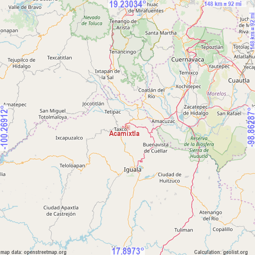
Acamixtla GPS coordinates[2]
18° 33' 54.432" North, 99° 33' 57.564" West
| Map corner | latitude | longitude |
|---|---|---|
| Upper-left | 19.23034°, | -100.26912° |
| Center: | 18.56512°, | -99.56599° |
| Lower-right: | 17.8973°, | -98.86287° |
| Map W x H: | 148.2×148.2 km | = 92.1×92.1mi |
| max Lat: | 32.7° ⇑71.8% North |
| Acamixtla: | 18.56512° |
| min Lat: | ⇓28.2% South 14.53588° |
| min Long | Acamixtla | max Long |
| -117.105° | -99.56599° | -86.73105° |
| W 42.1%⇐ | ⇒57.9% E |
Elevation
Elevation of Acamixtla is 1594 m = 5230 ft, and this is 340.3 m = 1116 ft above average elevation for this country.
| Max E: |
3497 m = 11473 ft | 44.8% |
| Acamixtla | 1594 m 5230 ft | |
| Avg. | 1253.7 m = 4113 ft | |
Min E: |
-1 m = -3 ft | 55.2% |
See also: Mexico elevation on elevation.city.
Geographical zone
Acamixtla is located in North Torrid zone (between Equator and Tropic of Cancer). Distance of this Northern Tropic circle is 541.7 km =336.6 mi to North.| Distance of | km | miles | from Acamixtla |
|---|---|---|---|
| North Pole | 7942.8 | 4935.4 | to North |
| Arctic Circle | 5336.9 | 3316.2 | to North |
| Tropic Cancer | 541.7 | 336.6 | to North |
| Equator | 2064.2 | 1282.6 | to South |


Nearby cities:
15 places around Acamixtla: (largest is in red/bold)
• Acuitlapan
4.7 km =2.9 mi,  31°
31°
• Axixintla
6.5 km =4 mi,  50°
50°
• Cacalotenango
8.4 km =5.2 mi,  255°
255°
• Colonia las Martelas
2.3 km =1.4 mi,  267°
267°
• Dolores
7.7 km =4.8 mi,  223°
223°
• El Ejido (Ejido Guerrero)
7.9 km =4.9 mi,  210°
210°
• Huajojutla (El Azul)
1.7 km =1.1 mi,  334°
334°
• Juliantla
3 km =1.9 mi,  157°
157°
• San Gregorio
7.8 km =4.8 mi,  337°
337°
• San Juan de Dios (Naranjas de Dios)
2 km =1.2 mi,  147°
147°
• Taxco de Alarcón
4.4 km =2.7 mi,  254°
254°
• Taxco el Viejo
9.3 km =5.8 mi,  191°
191°
• Tecalpulco
9.4 km =5.8 mi,  204°
204°
• Tehuilotepec
2.2 km =1.4 mi,  226°
226°
• Texcaltitla
8.5 km =5.3 mi,  78°
78°
Sources, notices
• [Note1] Compared only with cities in Mexico existing in our database
• [Src1] Map data: © OpenStreetMap contributors (CC-BY-SA)
• [Src2] Other city data from geonames.org with taken over terms of usage.
• [Src3] Geographical zone / Annual Mean Temperature by Robert A. Rohde @ Wikipedia
