Pueblo Viejo geodata
Pueblo Viejo (Oaxaca) is a populated place; located in Mexico in America/Mexico_City (GMT-6) time zone. With population of 1,406 people, there are 6155 cities with bigger population in this country. Compared to other cities in Mexico, 79.6% of cities are located further ↑North; 82% of cities are located further ←West and 81.4% of cities have higher elevation than Pueblo Viejo. Note1


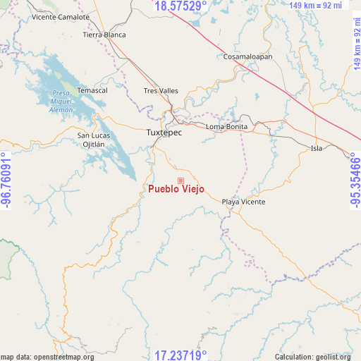
Pueblo Viejo GPS coordinates[2]
17° 54' 27" North, 96° 3' 28.008" West
| Map corner | latitude | longitude |
|---|---|---|
| Upper-left | 18.57529°, | -96.76091° |
| Center: | 17.9075°, | -96.05778° |
| Lower-right: | 17.23719°, | -95.35466° |
| Map W x H: | 148.8×148.8 km | = 92.5×92.5mi |
| max Lat: | 32.7° ⇑79.6% North |
| Pueblo Viejo: | 17.9075° |
| min Lat: | ⇓20.4% South 14.53588° |
| min Long | Pueblo Viejo | max Long |
| -117.105° | -96.05778° | -86.73105° |
| W 82%⇐ | ⇒18% E |
Elevation
Elevation of Pueblo Viejo is 77 m = 253 ft, and this is 1176.7 m = 3861 ft below average elevation for this country.
| Max E: |
3497 m = 11473 ft | 81.4% |
| Avg. | 1253.7 m = 4113 ft | |
| Pueblo Viejo | 77 m = 253 ft | |
Min E: |
-1 m = -3 ft | 18.6% |
See also: Mexico elevation on elevation.city.
Geographical zone
Pueblo Viejo is located in North Torrid zone (between Equator and Tropic of Cancer). Distance of this Northern Tropic circle is 614.8 km =382 mi to North.| Distance of | km | miles | from Pueblo Viejo |
|---|---|---|---|
| North Pole | 8015.9 | 4980.8 | to North |
| Arctic Circle | 5410 | 3361.6 | to North |
| Tropic Cancer | 614.8 | 382 | to North |
| Equator | 1991.1 | 1237.2 | to South |


Nearby cities:
15 places around Pueblo Viejo: (largest is in red/bold)
• Arroyo Choápam
12.6 km =7.8 mi,  303°
303°
• Arroyo Frijol
13.6 km =8.5 mi,  277°
277°
• Arroyo Limón
10.2 km =6.3 mi,  94°
94°
• Bethania
5.8 km =3.6 mi,  76°
76°
• Camalotal
6.5 km =4 mi,  26°
26°
• El Cedral
12.5 km =7.8 mi,  352°
352°
• Esperanza Arroyo la Gloria
10.7 km =6.6 mi,  53°
53°
• La Mina
9.9 km =6.2 mi,  333°
333°
• La Reforma
4.7 km =2.9 mi,  341°
341°
• Mata de Caña
15.2 km =9.4 mi, 335°
• Pueblo Nuevo Ojo de Agua
14.9 km =9.3 mi,  95°
95°
• Rodeo Arroyo Pepesca
6.4 km =4 mi, 339°
• San Isidro Naranjal
7.6 km =4.7 mi,  254°
254°
• San José Chiltepec
12.6 km =7.8 mi,  290°
290°
• Santa María Obispo
10.5 km =6.5 mi,  14°
14°
Sources, notices
• [Note1] Compared only with cities in Mexico existing in our database
• [Src1] Map data: © OpenStreetMap contributors (CC-BY-SA)
• [Src2] Other city data from geonames.org with taken over terms of usage.
• [Src3] Geographical zone / Annual Mean Temperature by Robert A. Rohde @ Wikipedia
