La Mina geodata
La Mina (Oaxaca) is a populated place; located in Mexico in America/Mexico_City (GMT-6) time zone. With population of 1,480 people, there are 5826 cities with bigger population in this country. Compared to other cities in Mexico, 78.8% of cities are located further ↑North; 81.8% of cities are located further ←West and 84.3% of cities have higher elevation than La Mina. Note1


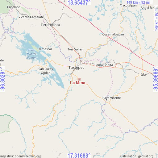
La Mina GPS coordinates[2]
17° 59' 12.804" North, 96° 5' 59.208" West
| Map corner | latitude | longitude |
|---|---|---|
| Upper-left | 18.65437°, | -96.80291° |
| Center: | 17.98689°, | -96.09978° |
| Lower-right: | 17.31688°, | -95.39666° |
| Map W x H: | 148.7×148.7 km | = 92.4×92.4mi |
| max Lat: | 32.7° ⇑78.8% North |
| La Mina: | 17.98689° |
| min Lat: | ⇓21.2% South 14.53588° |
| min Long | La Mina | max Long |
| -117.105° | -96.09978° | -86.73105° |
| W 81.8%⇐ | ⇒18.2% E |
Elevation
Elevation of La Mina is 50 m = 164 ft, and this is 1203.7 m = 3949 ft below average elevation for this country.
| Max E: |
3497 m = 11473 ft | 84.3% |
| Avg. | 1253.7 m = 4113 ft | |
| La Mina | 50 m = 164 ft | |
Min E: |
-1 m = -3 ft | 15.7% |
See also: Mexico elevation on elevation.city.
Geographical zone
La Mina is located in North Torrid zone (between Equator and Tropic of Cancer). Distance of this Northern Tropic circle is 606 km =376.6 mi to North.| Distance of | km | miles | from La Mina |
|---|---|---|---|
| North Pole | 8007.1 | 4975.4 | to North |
| Arctic Circle | 5401.2 | 3356.1 | to North |
| Tropic Cancer | 606 | 376.6 | to North |
| Equator | 2000 | 1242.7 | to South |


Nearby cities:
15 places around La Mina: (largest is in red/bold)
• Arroyo Choápam
6.3 km =3.9 mi,  253°
253°
• Arroyo Frijol
11.5 km =7.1 mi,  231°
231°
• Camalotal
7.9 km =4.9 mi,  112°
112°
• El Cedral
4.4 km =2.7 mi,  37°
37°
• Fortino J. Pinacho
7.9 km =4.9 mi,  272°
272°
• La Reforma
5.3 km =3.3 mi,  145°
145°
• Mata de Caña
5.3 km =3.3 mi,  340°
340°
• Pueblo Viejo
9.9 km =6.2 mi, 153°
• Rodeo Arroyo Pepesca
3.6 km =2.2 mi,  141°
141°
• San Bartolo
11.7 km =7.3 mi,  356°
356°
• San Isidro Naranjal
11.2 km =7 mi,  194°
194°
• San José Chiltepec
8.6 km =5.3 mi,  239°
239°
• Santa María Obispo
7.3 km =4.5 mi,  79°
79°
• Sebastopol
9.3 km =5.8 mi,  303°
303°
• Tuxtepec
11.6 km =7.2 mi,  346°
346°
Sources, notices
• [Note1] Compared only with cities in Mexico existing in our database
• [Src1] Map data: © OpenStreetMap contributors (CC-BY-SA)
• [Src2] Other city data from geonames.org with taken over terms of usage.
• [Src3] Geographical zone / Annual Mean Temperature by Robert A. Rohde @ Wikipedia
