Piedra Grande geodata
Piedra Grande (Oaxaca) is a populated place; located in Mexico in America/Mexico_City (GMT-6) time zone. With population of 961 people, there are 9056 cities with bigger population in this country. Compared to other cities in Mexico, 93.9% of cities are located further ↑North; 69.1% of cities are located further ←West and 64.4% of cities have higher elevation than Piedra Grande. Note1


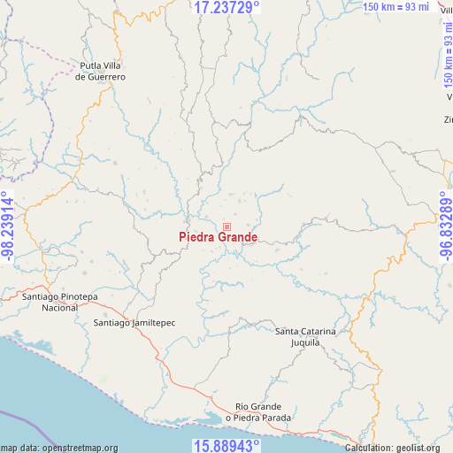
Piedra Grande GPS coordinates[2]
16° 33' 52.344" North, 97° 32' 9.636" West
| Map corner | latitude | longitude |
|---|---|---|
| Upper-left | 17.23729°, | -98.23914° |
| Center: | 16.56454°, | -97.53601° |
| Lower-right: | 15.88943°, | -96.83289° |
| Map W x H: | 149.9×149.9 km | = 93.1×93.1mi |
| max Lat: | 32.7° ⇑93.9% North |
| Piedra Grande: | 16.56454° |
| min Lat: | ⇓6.1% South 14.53588° |
| min Long | Piedra Grande | max Long |
| -117.105° | -97.53601° | -86.73105° |
| W 69.1%⇐ | ⇒30.9% E |
Elevation
Elevation of Piedra Grande is 722 m = 2369 ft, and this is 531.7 m = 1744 ft below average elevation for this country.
| Max E: |
3497 m = 11473 ft | 64.4% |
| Avg. | 1253.7 m = 4113 ft | |
| Piedra Grande | 722 m = 2369 ft | |
Min E: |
-1 m = -3 ft | 35.6% |
See also: Mexico elevation on elevation.city.
Geographical zone
Piedra Grande is located in North Torrid zone (between Equator and Tropic of Cancer). Distance of this Northern Tropic circle is 764.1 km =474.8 mi to North.| Distance of | km | miles | from Piedra Grande |
|---|---|---|---|
| North Pole | 8165.3 | 5073.7 | to North |
| Arctic Circle | 5559.4 | 3454.4 | to North |
| Tropic Cancer | 764.1 | 474.8 | to North |
| Equator | 1841.8 | 1144.4 | to South |


Nearby cities:
15 places around Piedra Grande: (largest is in red/bold)
• Colonia de Jesús (La Cucaracha)
10.4 km =6.5 mi,  33°
33°
• El Carrizal
10.5 km =6.5 mi,  110°
110°
• El Limoncillo
5.4 km =3.4 mi,  148°
148°
• El Mosco
13 km =8.1 mi,  258°
258°
• El Portillo
13.8 km =8.6 mi, 112°
• Llano Nuevo
5 km =3.1 mi,  35°
35°
• Mano del Señor
10.1 km =6.3 mi,  77°
77°
• Piedra del Tambor
10.7 km =6.6 mi,  8°
8°
• Pueblo Viejo
10.1 km =6.3 mi, 261°
• Quinicuena
3.9 km =2.4 mi,  160°
160°
• San José
10.3 km =6.4 mi,  126°
126°
• San Pedro del Río
8.4 km =5.2 mi,  136°
136°
• Santa Cruz Zenzontepec
5.5 km =3.4 mi, 128°
• Santiago Amoltepec
9.6 km =6 mi, 25°
• Santiago Ixtayutla
12.5 km =7.8 mi,  270°
270°
Sources, notices
• [Note1] Compared only with cities in Mexico existing in our database
• [Src1] Map data: © OpenStreetMap contributors (CC-BY-SA)
• [Src2] Other city data from geonames.org with taken over terms of usage.
• [Src3] Geographical zone / Annual Mean Temperature by Robert A. Rohde @ Wikipedia
