San Lorenzo geodata
San Lorenzo (Oaxaca) is a seat of a second-order administrative division; located in Mexico in America/Mexico_City (GMT-6) time zone. With population of 506 people, there are 16626 cities with bigger population in this country. Compared to other cities in Mexico, 81.6% of cities are located further ↑North; 62.3% of cities are located further ←West and 55.3% of cities have higher elevation than San Lorenzo. Note1


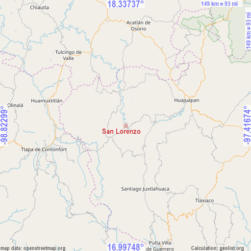
San Lorenzo GPS coordinates[2]
17° 40' 7.212" North, 98° 7' 11.496" West
| Map corner | latitude | longitude |
|---|---|---|
| Upper-left | 18.33737°, | -98.82299° |
| Center: | 17.66867°, | -98.11986° |
| Lower-right: | 16.99748°, | -97.41674° |
| Map W x H: | 149×149 km | = 92.6×92.6mi |
| max Lat: | 32.7° ⇑81.6% North |
| San Lorenzo: | 17.66867° |
| min Lat: | ⇓18.4% South 14.53588° |
| min Long | San Lorenzo | max Long |
| -117.105° | -98.11986° | -86.73105° |
| W 62.3%⇐ | ⇒37.7% E |
Elevation
Elevation of San Lorenzo is 1188 m = 3898 ft, and this is 65.7 m = 216 ft below average elevation for this country.
| Max E: |
3497 m = 11473 ft | 55.3% |
| Avg. | 1253.7 m = 4113 ft | |
| San Lorenzo | 1188 m = 3898 ft | |
Min E: |
-1 m = -3 ft | 44.7% |
See also: Mexico elevation on elevation.city.
Geographical zone
San Lorenzo is located in North Torrid zone (between Equator and Tropic of Cancer). Distance of this Northern Tropic circle is 641.3 km =398.5 mi to North.| Distance of | km | miles | from San Lorenzo |
|---|---|---|---|
| North Pole | 8042.5 | 4997.4 | to North |
| Arctic Circle | 5436.6 | 3378.1 | to North |
| Tropic Cancer | 641.3 | 398.5 | to North |
| Equator | 1964.6 | 1220.7 | to South |


Nearby cities:
15 places around San Lorenzo: (largest is in red/bold)
• Guadalupe Ramírez
11 km =6.8 mi,  334°
334°
• Guadalupe de Morelos
1.3 km =0.8 mi,  49°
49°
• Nicolás Hidalgo
13 km =8.1 mi,  348°
348°
• San Agustín Atenango
13.2 km =8.2 mi,  118°
118°
• San Andrés Sabinillo
12.4 km =7.7 mi, 49°
• San Jerónimo Nuchita
3.9 km =2.4 mi,  135°
135°
• San Jorge Nuchita
2.2 km =1.4 mi,  128°
128°
• San Luis Morelia
10.7 km =6.6 mi,  291°
291°
• San Martín Zacatepec
16.7 km =10.4 mi,  22°
22°
• San Sebastián del Monte
10.4 km =6.5 mi,  84°
84°
• Santa Cruz de Bravo
14.7 km =9.1 mi,  228°
228°
• Santo Domingo Tonalá
16.4 km =10.2 mi,  88°
88°
• Tamazola
10.7 km =6.6 mi,  270°
270°
• Yetla de Juárez
13.6 km =8.5 mi, 91°
• Yucuyachi
10.5 km =6.5 mi, 230°
Sources, notices
• [Note1] Compared only with cities in Mexico existing in our database
• [Src1] Map data: © OpenStreetMap contributors (CC-BY-SA)
• [Src2] Other city data from geonames.org with taken over terms of usage.
• [Src3] Geographical zone / Annual Mean Temperature by Robert A. Rohde @ Wikipedia
