La Patria geodata
La Patria (Oaxaca) is a populated place; located in Mexico in America/Mexico_City (GMT-6) time zone. With population of 703 people, there are 12379 cities with bigger population in this country. Compared to other cities in Mexico, 74.8% of cities are located further ↑North; 80.1% of cities are located further ←West and 82.3% of cities have higher elevation than La Patria. Note1


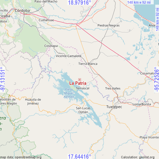
La Patria GPS coordinates[2]
18° 18' 46.62" North, 96° 25' 42.168" West
| Map corner | latitude | longitude |
|---|---|---|
| Upper-left | 18.97916°, | -97.13151° |
| Center: | 18.31295°, | -96.42838° |
| Lower-right: | 17.64416°, | -95.72526° |
| Map W x H: | 148.4×148.4 km | = 92.2×92.2mi |
| max Lat: | 32.7° ⇑74.8% North |
| La Patria: | 18.31295° |
| min Lat: | ⇓25.2% South 14.53588° |
| min Long | La Patria | max Long |
| -117.105° | -96.42838° | -86.73105° |
| W 80.1%⇐ | ⇒19.9% E |
Elevation
Elevation of La Patria is 67 m = 220 ft, and this is 1186.7 m = 3893 ft below average elevation for this country.
| Max E: |
3497 m = 11473 ft | 82.3% |
| Avg. | 1253.7 m = 4113 ft | |
| La Patria | 67 m = 220 ft | |
Min E: |
-1 m = -3 ft | 17.7% |
See also: Mexico elevation on elevation.city.
Geographical zone
La Patria is located in North Torrid zone (between Equator and Tropic of Cancer). Distance of this Northern Tropic circle is 569.7 km =354 mi to North.| Distance of | km | miles | from La Patria |
|---|---|---|---|
| North Pole | 7970.9 | 4952.9 | to North |
| Arctic Circle | 5365 | 3333.7 | to North |
| Tropic Cancer | 569.7 | 354 | to North |
| Equator | 2036.2 | 1265.2 | to South |


Nearby cities:
15 places around La Patria: (largest is in red/bold)
• Arroyo de Pita
11.3 km =7 mi,  38°
38°
• Cabeza de Tigre
1.1 km =0.7 mi,  197°
197°
• El Cedral
8.1 km =5 mi,  317°
317°
• El Encajonado
9.2 km =5.7 mi,  151°
151°
• La Reforma
10 km =6.2 mi,  97°
97°
• La Reforma
11.9 km =7.4 mi,  94°
94°
• La Tabaquera
3.5 km =2.2 mi, 316°
• Nuevo Paso Nacional
8.5 km =5.3 mi,  156°
156°
• Nuevo Paso Nazareno (Chichicazapa)
8.8 km =5.5 mi, 101°
• Nuevo Pescadito de Abajo
11.5 km =7.1 mi,  136°
136°
• Nuevo Pescadito de Enmedio
7 km =4.3 mi,  131°
131°
• Nuevo Pescadito de Málzaga (La Breña)
6.7 km =4.2 mi,  48°
48°
• Rancho Grande
9.5 km =5.9 mi,  61°
61°
• Temascal
8.3 km =5.2 mi, 160°
• Tembladera del Castillo
11.7 km =7.3 mi, 320°
Sources, notices
• [Note1] Compared only with cities in Mexico existing in our database
• [Src1] Map data: © OpenStreetMap contributors (CC-BY-SA)
• [Src2] Other city data from geonames.org with taken over terms of usage.
• [Src3] Geographical zone / Annual Mean Temperature by Robert A. Rohde @ Wikipedia
