La Reforma geodata
La Reforma (Oaxaca) is a populated place; located in Mexico in America/Mexico_City (GMT-6) time zone. With population of 552 people, there are 15449 cities with bigger population in this country. Compared to other cities in Mexico, 74.9% of cities are located further ↑North; 80.7% of cities are located further ←West and 86.1% of cities have higher elevation than La Reforma. Note1


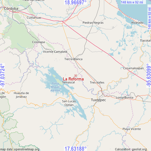
La Reforma GPS coordinates[2]
18° 18' 2.556" North, 96° 20' 2.796" West
| Map corner | latitude | longitude |
|---|---|---|
| Upper-left | 18.96697°, | -97.03724° |
| Center: | 18.30071°, | -96.33411° |
| Lower-right: | 17.63188°, | -95.63099° |
| Map W x H: | 148.4×148.5 km | = 92.2×92.3mi |
| max Lat: | 32.7° ⇑74.9% North |
| La Reforma: | 18.30071° |
| min Lat: | ⇓25.1% South 14.53588° |
| min Long | La Reforma | max Long |
| -117.105° | -96.33411° | -86.73105° |
| W 80.7%⇐ | ⇒19.3% E |
Elevation
Elevation of La Reforma is 38 m = 125 ft, and this is 1215.7 m = 3989 ft below average elevation for this country.
| Max E: |
3497 m = 11473 ft | 86.1% |
| Avg. | 1253.7 m = 4113 ft | |
| La Reforma | 38 m = 125 ft | |
Min E: |
-1 m = -3 ft | 13.9% |
See also: Mexico elevation on elevation.city.
Geographical zone
La Reforma is located in North Torrid zone (between Equator and Tropic of Cancer). Distance of this Northern Tropic circle is 571.1 km =354.9 mi to North.| Distance of | km | miles | from La Reforma |
|---|---|---|---|
| North Pole | 7972.2 | 4953.7 | to North |
| Arctic Circle | 5366.3 | 3334.5 | to North |
| Tropic Cancer | 571.1 | 354.9 | to North |
| Equator | 2034.8 | 1264.4 | to South |


Nearby cities:
15 places around La Reforma: (largest is in red/bold)
• Arroyo Chical (Nuevo Arroyo Chicali)
9.4 km =5.8 mi,  181°
181°
• Corral de Piedra
6.9 km =4.3 mi,  153°
153°
• El Capulín (La Nueva Pochota)
9.9 km =6.2 mi,  143°
143°
• El Encajonado
8.7 km =5.4 mi,  219°
219°
• La Granja
9.9 km =6.2 mi,  52°
52°
• La Reforma
1.9 km =1.2 mi,  79°
79°
• Las Margaritas
7.3 km =4.5 mi,  133°
133°
• Nuevo Paso Nacional
9.2 km =5.7 mi,  225°
225°
• Nuevo Paso Nazareno (Chichicazapa)
1.5 km =0.9 mi,  252°
252°
• Nuevo Pescadito de Abajo
7.3 km =4.5 mi,  196°
196°
• Nuevo Pescadito de Enmedio
5.8 km =3.6 mi, 234°
• Nuevo Pescadito de Málzaga (La Breña)
7.7 km =4.8 mi,  319°
319°
• Paso Rincón
6 km =3.7 mi, 129°
• Rancho Grande
6.1 km =3.8 mi,  344°
344°
• Temascal
9.6 km =6 mi, 227°
Sources, notices
• [Note1] Compared only with cities in Mexico existing in our database
• [Src1] Map data: © OpenStreetMap contributors (CC-BY-SA)
• [Src2] Other city data from geonames.org with taken over terms of usage.
• [Src3] Geographical zone / Annual Mean Temperature by Robert A. Rohde @ Wikipedia
