Nuevo Paso Nacional geodata
Nuevo Paso Nacional (Oaxaca) is a populated place; located in Mexico in America/Mexico_City (GMT-6) time zone. With population of 644 people, there are 13427 cities with bigger population in this country. Compared to other cities in Mexico, 75.6% of cities are located further ↑North; 80.3% of cities are located further ←West and 85.5% of cities have higher elevation than Nuevo Paso Nacional. Note1


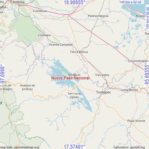
Nuevo Paso Nacional GPS coordinates[2]
18° 14' 35.016" North, 96° 23' 48.012" West
| Map corner | latitude | longitude |
|---|---|---|
| Upper-left | 18.90955°, | -97.0998° |
| Center: | 18.24306°, | -96.39667° |
| Lower-right: | 17.57401°, | -95.69355° |
| Map W x H: | 148.5×148.5 km | = 92.3×92.3mi |
| max Lat: | 32.7° ⇑75.6% North |
| Nuevo Paso Nacional: | 18.24306° |
| min Lat: | ⇓24.4% South 14.53588° |
| min Long | Nuevo Paso Naci | max Long |
| -117.105° | -96.39667° | -86.73105° |
| W 80.3%⇐ | ⇒19.7% E |
Elevation
Elevation of Nuevo Paso Nacional is 41 m = 135 ft, and this is 1212.7 m = 3979 ft below average elevation for this country.
| Max E: |
3497 m = 11473 ft | 85.5% |
| Avg. | 1253.7 m = 4113 ft | |
| Nuevo Paso Nacional | 41 m = 135 ft | |
Min E: |
-1 m = -3 ft | 14.5% |
See also: Mexico elevation on elevation.city.
Geographical zone
Nuevo Paso Nacional is located in North Torrid zone (between Equator and Tropic of Cancer). Distance of this Northern Tropic circle is 577.5 km =358.8 mi to North.| Distance of | km | miles | from Nuevo Paso Nacional |
|---|---|---|---|
| North Pole | 7978.6 | 4957.7 | to North |
| Arctic Circle | 5372.7 | 3338.4 | to North |
| Tropic Cancer | 577.5 | 358.8 | to North |
| Equator | 2028.4 | 1260.4 | to South |


Nearby cities:
15 places around Nuevo Paso Nacional: (largest is in red/bold)
• Arroyo Chical (Nuevo Arroyo Chicali)
7 km =4.3 mi,  115°
115°
• Cabeza de Tigre
7.7 km =4.8 mi,  331°
331°
• Corral de Piedra
9.6 km =6 mi,  88°
88°
• El Encajonado
1.1 km =0.7 mi,  105°
105°
• Isla Soyaltepec
10.3 km =6.4 mi,  242°
242°
• La Patria
8.5 km =5.3 mi,  336°
336°
• La Reforma
9.2 km =5.7 mi,  45°
45°
• La Reforma
10.9 km =6.8 mi, 51°
• La Tabaquera
11.8 km =7.3 mi, 330°
• Nuevo Paso Nazareno (Chichicazapa)
7.9 km =4.9 mi,  41°
41°
• Nuevo Pescadito de Abajo
4.6 km =2.9 mi,  97°
97°
• Nuevo Pescadito de Abajo Dos
10.7 km =6.6 mi,  182°
182°
• Nuevo Pescadito de Enmedio
3.6 km =2.2 mi,  31°
31°
• Paso Rincón
11.5 km =7.1 mi,  77°
77°
• Temascal
0.5 km =0.3 mi,  267°
267°
Sources, notices
• [Note1] Compared only with cities in Mexico existing in our database
• [Src1] Map data: © OpenStreetMap contributors (CC-BY-SA)
• [Src2] Other city data from geonames.org with taken over terms of usage.
• [Src3] Geographical zone / Annual Mean Temperature by Robert A. Rohde @ Wikipedia
