Arroyo Metate geodata
Arroyo Metate (Oaxaca) is a populated place; located in Mexico in America/Mexico_City (GMT-6) time zone. With population of 964 people, there are 9028 cities with bigger population in this country. Compared to other cities in Mexico, 78.6% of cities are located further ↑North; 82.4% of cities are located further ←West and 82.4% of cities have higher elevation than Arroyo Metate. Note1


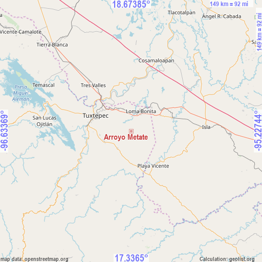
Arroyo Metate GPS coordinates[2]
18° 0' 23.184" North, 95° 55' 50.016" West
| Map corner | latitude | longitude |
|---|---|---|
| Upper-left | 18.67385°, | -96.63369° |
| Center: | 18.00644°, | -95.93056° |
| Lower-right: | 17.3365°, | -95.22744° |
| Map W x H: | 148.7×148.7 km | = 92.4×92.4mi |
| max Lat: | 32.7° ⇑78.6% North |
| Arroyo Metate: | 18.00644° |
| min Lat: | ⇓21.4% South 14.53588° |
| min Long | Arroyo Metate | max Long |
| -117.105° | -95.93056° | -86.73105° |
| W 82.4%⇐ | ⇒17.6% E |
Elevation
Elevation of Arroyo Metate is 66 m = 217 ft, and this is 1187.7 m = 3897 ft below average elevation for this country.
| Max E: |
3497 m = 11473 ft | 82.4% |
| Avg. | 1253.7 m = 4113 ft | |
| Arroyo Metate | 66 m = 217 ft | |
Min E: |
-1 m = -3 ft | 17.6% |
See also: Mexico elevation on elevation.city.
Geographical zone
Arroyo Metate is located in North Torrid zone (between Equator and Tropic of Cancer). Distance of this Northern Tropic circle is 603.8 km =375.2 mi to North.| Distance of | km | miles | from Arroyo Metate |
|---|---|---|---|
| North Pole | 8004.9 | 4974 | to North |
| Arctic Circle | 5399 | 3354.8 | to North |
| Tropic Cancer | 603.8 | 375.2 | to North |
| Equator | 2002.1 | 1244 | to South |


Nearby cities:
15 places around Arroyo Metate: (largest is in red/bold)
• Arroyo Limón
12.3 km =7.6 mi,  195°
195°
• Benemérito Juárez
14.7 km =9.1 mi,  329°
329°
• Bethania
12.4 km =7.7 mi,  218°
218°
• Camalotal
11.8 km =7.3 mi,  244°
244°
• El Cedral
15.2 km =9.4 mi,  275°
275°
• Esperanza Arroyo la Gloria
6.7 km =4.2 mi,  226°
226°
• La Reforma
16.3 km =10.1 mi,  246°
246°
• La Soledad
16.6 km =10.3 mi,  159°
159°
• Loma Bonita
12.5 km =7.8 mi,  25°
25°
• Mixtán
13 km =8.1 mi,  144°
144°
• Pueblo Nuevo Ojo de Agua
12.6 km =7.8 mi,  173°
173°
• Pueblo Viejo
17.4 km =10.8 mi, 230°
• Rodeo Arroyo Pepesca
16.4 km =10.2 mi, 252°
• San Benito Encinal
3 km =1.9 mi, 135°
• Santa María Obispo
10.8 km =6.7 mi,  265°
265°
Sources, notices
• [Note1] Compared only with cities in Mexico existing in our database
• [Src1] Map data: © OpenStreetMap contributors (CC-BY-SA)
• [Src2] Other city data from geonames.org with taken over terms of usage.
• [Src3] Geographical zone / Annual Mean Temperature by Robert A. Rohde @ Wikipedia
