Frontera geodata
Frontera (Tabasco) is a populated place; located in Mexico in America/Mexico_City (GMT-6) time zone. With population of 22,795 people, there are 451 cities with bigger population in this country. Compared to other cities in Mexico, 72.1% of cities are located further ↑North; 90.8% of cities are located further ←West and 99.3% of cities have higher elevation than Frontera. Note1


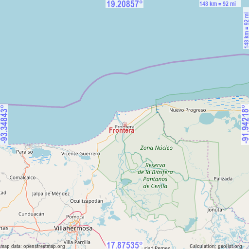
Frontera GPS coordinates[2]
18° 32' 35.736" North, 92° 38' 43.08" West
| Map corner | latitude | longitude |
|---|---|---|
| Upper-left | 19.20857°, | -93.34843° |
| Center: | 18.54326°, | -92.6453° |
| Lower-right: | 17.87535°, | -91.94218° |
| Map W x H: | 148.2×148.2 km | = 92.1×92.1mi |
| max Lat: | 32.7° ⇑72.1% North |
| Frontera: | 18.54326° |
| min Lat: | ⇓27.9% South 14.53588° |
| min Long | Frontera | max Long |
| -117.105° | -92.6453° | -86.73105° |
| W 90.8%⇐ | ⇒9.2% E |
Elevation
Elevation of Frontera is 5 m = 16 ft, and this is 1248.7 m = 4097 ft below average elevation for this country.
| Max E: |
3497 m = 11473 ft | 99.3% |
| Avg. | 1253.7 m = 4113 ft | |
| Frontera | 5 m = 16 ft | |
Min E: |
-1 m = -3 ft | 0.7% |
See also: Mexico elevation on elevation.city.
Geographical zone
Frontera is located in North Torrid zone (between Equator and Tropic of Cancer). Distance of this Northern Tropic circle is 544.1 km =338.1 mi to North.| Distance of | km | miles | from Frontera |
|---|---|---|---|
| North Pole | 7945.2 | 4936.9 | to North |
| Arctic Circle | 5339.4 | 3317.7 | to North |
| Tropic Cancer | 544.1 | 338.1 | to North |
| Equator | 2061.8 | 1281.1 | to South |


Nearby cities:
15 places around Frontera: (largest is in red/bold)
• Benito Juárez
21.1 km =13.1 mi,  231°
231°
• Carlos Rovirosa 1ra. Sección
2.9 km =1.8 mi,  0°
0°
• Constancia y Venecia
22.3 km =13.9 mi,  237°
237°
• Ejido Benito Juárez
21 km =13 mi, 240°
• Francisco I. Madero
12.4 km =7.7 mi, 228°
• Frontera
23.7 km =14.7 mi, 233°
• José María Morelos y Pavón
25.8 km =16 mi, 236°
• La Estrella
9.4 km =5.8 mi,  44°
44°
• La Victoria
5.5 km =3.4 mi,  13°
13°
• Nuevo Centla
15.4 km =9.6 mi,  54°
54°
• Ribera Alta 1ra. Sección
24.9 km =15.5 mi,  153°
153°
• Ribera Alta 2da. Sección (Salsipuedes)
25.2 km =15.7 mi, 145°
• San José del Carmen
20.4 km =12.7 mi, 227°
• Álvaro Obregón (Santa Cruz)
23.2 km =14.4 mi,  224°
224°
• Álvaro Obregón 2da. Sección (El Lechugal)
22.7 km =14.1 mi, 222°
Sources, notices
• [Note1] Compared only with cities in Mexico existing in our database
• [Src1] Map data: © OpenStreetMap contributors (CC-BY-SA)
• [Src2] Other city data from geonames.org with taken over terms of usage.
• [Src3] Geographical zone / Annual Mean Temperature by Robert A. Rohde @ Wikipedia
