La Curva geodata
La Curva (Tabasco) is a populated place; located in Mexico in America/Mexico_City (GMT-6) time zone. With population of 5,651 people, there are 1648 cities with bigger population in this country. Compared to other cities in Mexico, 80% of cities are located further ↑North; 91.9% of cities are located further ←West and 97.5% of cities have higher elevation than La Curva. Note1


La Curva GPS coordinates[2]
17° 51' 57.744" North, 92° 29' 17.304" West
| Map corner | latitude | longitude |
|---|---|---|
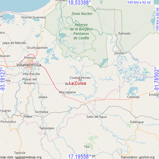
| Upper-left | 18.53398°, | -93.19127° |
| Center: | 17.86604°, | -92.48814° |
| Lower-right: | 17.19558°, | -91.78502° |
| Map W x H: | 148.8×148.8 km | = 92.5×92.5mi |
| max Lat: | 32.7° ⇑80% North |
| La Curva: | 17.86604° |
| min Lat: | ⇓20% South 14.53588° |
| min Long | La Curva | max Long |
| -117.105° | -92.48814° | -86.73105° |
| W 91.9%⇐ | ⇒8.1% E |
Elevation
Elevation of La Curva is 9 m = 30 ft, and this is 1244.7 m = 4084 ft below average elevation for this country.
| Max E: |
3497 m = 11473 ft | 97.5% |
| Avg. | 1253.7 m = 4113 ft | |
| La Curva | 9 m = 30 ft | |
Min E: |
-1 m = -3 ft | 2.5% |
See also: Mexico elevation on elevation.city.
Geographical zone
La Curva is located in North Torrid zone (between Equator and Tropic of Cancer). Distance of this Northern Tropic circle is 619.4 km =384.9 mi to North.| Distance of | km | miles | from La Curva |
|---|---|---|---|
| North Pole | 8020.5 | 4983.7 | to North |
| Arctic Circle | 5414.7 | 3364.5 | to North |
| Tropic Cancer | 619.4 | 384.9 | to North |
| Equator | 1986.5 | 1234.4 | to South |


Nearby cities:
15 places around La Curva: (largest is in red/bold)
• Aquiles Serdán (San Fernando)
6.7 km =4.2 mi,  181°
181°
• Buenavista
7.4 km =4.6 mi,  319°
319°
• Cacahuatalillo
7.2 km =4.5 mi,  217°
217°
• Ciudad Pemex
1.9 km =1.2 mi,  13°
13°
• El Bayo 1ra. Sección (Granada)
3.4 km =2.1 mi,  193°
193°
• El Bayo 2da. Sección
1.5 km =0.9 mi,  67°
67°
• El Congo
6.9 km =4.3 mi,  131°
131°
• Hermenegildo Galeana (Chiveros)
2.8 km =1.7 mi,  49°
49°
• José Colomo
9.3 km =5.8 mi, 14°
• La Escalera
4.7 km =2.9 mi,  237°
237°
• La Unión
2.1 km =1.3 mi,  203°
203°
• Limón 1ra. Sección Sector B
2.8 km =1.7 mi,  342°
342°
• Nueva División del Bayo (Guatemala)
2.9 km =1.8 mi, 181°
• Nueva Esperanza
5.9 km =3.7 mi,  278°
278°
• San Carlos
5.7 km =3.5 mi,  230°
230°
Sources, notices
• [Note1] Compared only with cities in Mexico existing in our database
• [Src1] Map data: © OpenStreetMap contributors (CC-BY-SA)
• [Src2] Other city data from geonames.org with taken over terms of usage.
• [Src3] Geographical zone / Annual Mean Temperature by Robert A. Rohde @ Wikipedia
