Buenavista geodata
Buenavista (Tabasco) is a populated place; located in Mexico in America/Mexico_City (GMT-6) time zone. With population of 4,468 people, there are 2061 cities with bigger population in this country. Compared to other cities in Mexico, 79.5% of cities are located further ↑North; 91.6% of cities are located further ←West and 100% of cities have higher elevation than Buenavista. Note1


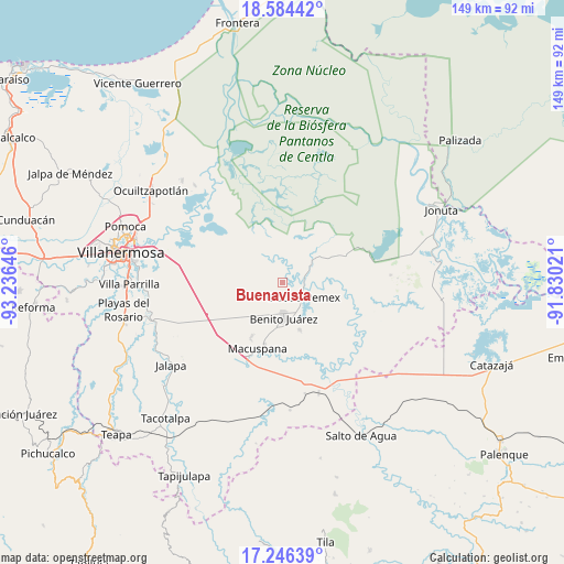
Buenavista GPS coordinates[2]
17° 55' 0.012" North, 92° 31' 59.988" West
| Map corner | latitude | longitude |
|---|---|---|
| Upper-left | 18.58442°, | -93.23646° |
| Center: | 17.91667°, | -92.53333° |
| Lower-right: | 17.24639°, | -91.83021° |
| Map W x H: | 148.8×148.8 km | = 92.5×92.5mi |
| max Lat: | 32.7° ⇑79.5% North |
| Buenavista: | 17.91667° |
| min Lat: | ⇓20.5% South 14.53588° |
| min Long | Buenavista | max Long |
| -117.105° | -92.53333° | -86.73105° |
| W 91.6%⇐ | ⇒8.4% E |
Elevation
Elevation of Buenavista is 1 m = 3 ft, and this is 1252.7 m = 4110 ft below average elevation for this country.
| Max E: |
3497 m = 11473 ft | 100% |
| Avg. | 1253.7 m = 4113 ft | |
| Buenavista | 1 m = 3 ft | |
Min E: |
-1 m = -3 ft | 0% |
See also: Mexico elevation on elevation.city.
Geographical zone
Buenavista is located in North Torrid zone (between Equator and Tropic of Cancer). Distance of this Northern Tropic circle is 613.8 km =381.4 mi to North.| Distance of | km | miles | from Buenavista |
|---|---|---|---|
| North Pole | 8014.9 | 4980.2 | to North |
| Arctic Circle | 5409 | 3361 | to North |
| Tropic Cancer | 613.8 | 381.4 | to North |
| Equator | 1992.1 | 1237.8 | to South |


Nearby cities:
15 places around Buenavista: (largest is in red/bold)
• Ciudad Pemex
6.4 km =4 mi,  125°
125°
• El Bayo 1ra. Sección (Granada)
9.8 km =6.1 mi,  156°
156°
• El Bayo 2da. Sección
8 km =5 mi, 129°
• Emiliano Zapata 2da. Sección
9.6 km =6 mi,  221°
221°
• Hermenegildo Galeana (Chiveros)
7.9 km =4.9 mi,  118°
118°
• José Colomo
7.8 km =4.8 mi,  64°
64°
• La Curva
7.4 km =4.6 mi,  139°
139°
• La Escalera
8.2 km =5.1 mi,  174°
174°
• La Unión
8.5 km =5.3 mi,  152°
152°
• Limón 1ra. Sección Sector B
4.9 km =3 mi, 126°
• Morelos
6.9 km =4.3 mi,  274°
274°
• Nueva División del Bayo (Guatemala)
9.7 km =6 mi, 151°
• Nueva Esperanza
4.9 km =3 mi,  192°
192°
• San Carlos
9.3 km =5.8 mi,  177°
177°
• Veinte de Noviembre
9.7 km =6 mi, 217°
Sources, notices
• [Note1] Compared only with cities in Mexico existing in our database
• [Src1] Map data: © OpenStreetMap contributors (CC-BY-SA)
• [Src2] Other city data from geonames.org with taken over terms of usage.
• [Src3] Geographical zone / Annual Mean Temperature by Robert A. Rohde @ Wikipedia
